You are here: Home > Network List > US - United States National Seismic Network Stations List
> Station WVOR Wild Horse Valley, Oregon, USA > Earthquake Result Viewer
WVOR Wild Horse Valley, Oregon, USA - Earthquake Result Viewer
| Earthquake location: |
New Britain Region, P.N.G. |
| Earthquake latitude/longitude: |
-5.4/151.9 |
| Earthquake time(UTC): |
2003/07/03 (184) 13:06:14 GMT |
| Earthquake Depth: |
10 km |
| Earthquake Magnitude: |
5.5 MB, 5.3 MS, 5.7 MW |
| Earthquake Catalog/Contributor: |
WHDF/NEIC |
|
| Network: |
US United States National Seismic Network |
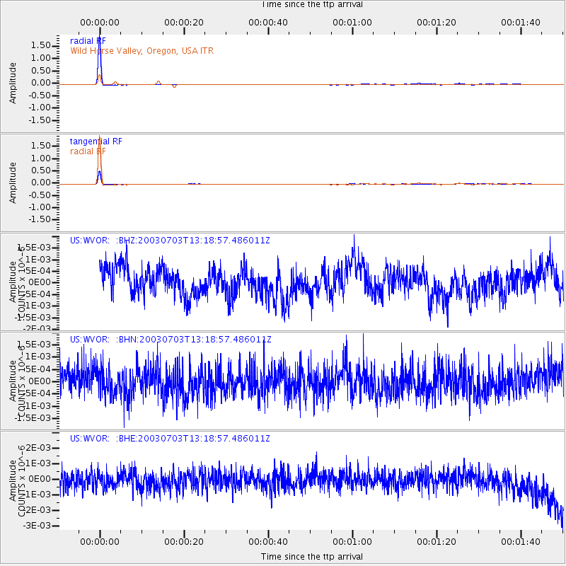
| Station: |
WVOR Wild Horse Valley, Oregon, USA |
| Lat/Lon: |
42.43 N/118.64 W |
| Elevation: |
1344 m |
|
| Distance: |
93.3 deg |
| Az: |
47.857 deg |
| Baz: |
265.644 deg |
| Ray Param: |
0.041296884 |
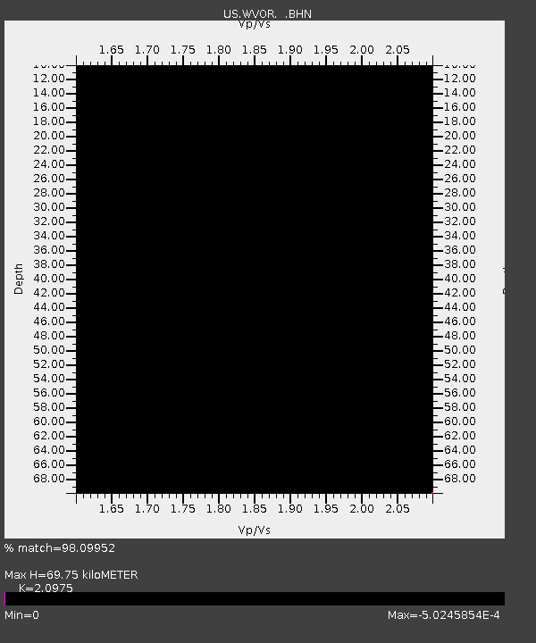
| Estimated Moho Depth: |
69.75 km |
| Estimated Crust Vp/Vs: |
2.10 |
| Assumed Crust Vp: |
6.279 km/s |
| Estimated Crust Vs: |
2.993 km/s |
| Estimated Crust Poisson's Ratio: |
0.35 |
|
| Radial Match: |
98.09952 % |
| Radial Bump: |
79 |
| Transverse Match: |
95.726326 % |
| Transverse Bump: |
92 |
| SOD ConfigId: |
110165 |
| Insert Time: |
2010-03-05 04:20:35.276 +0000 |
| GWidth: |
2.5 |
| Max Bumps: |
400 |
| Tol: |
0.001 |
|
Signal To Noise
| Channel | StoN | STA | LTA |
| US:WVOR: :BHN:20030703T13:18:57.486011Z | 1.0217263 | 5.0239135E-10 | 4.9170834E-10 |
| US:WVOR: :BHE:20030703T13:18:57.486011Z | 0.89904636 | 4.7546783E-10 | 5.2885796E-10 |
| US:WVOR: :BHZ:20030703T13:18:57.486011Z | 1.0782543 | 6.26984E-10 | 5.814806E-10 |
| Arrivals |
| Ps | 12 SECOND |
| PpPs | 34 SECOND |
| PsPs/PpSs | 46 SECOND |


