You are here: Home > Network List > TA - USArray Transportable Network (new EarthScope stations) Stations List
> Station N23A Red Feather Lakes, CO, USA > Earthquake Result Viewer
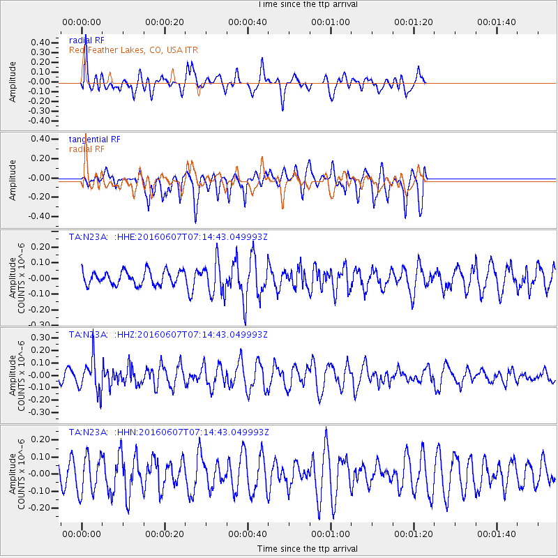
N23A Red Feather Lakes, CO, USA - Earthquake Result Viewer
*The percent match for this event was below the threshold and hence no stack was calculated.
| Earthquake location: |
South Of Fiji Islands |
| Earthquake latitude/longitude: |
-23.7/-179.9 |
| Earthquake time(UTC): |
2016/06/07 (159) 07:02:52 GMT |
| Earthquake Depth: |
523 km |
| Earthquake Magnitude: |
5.5 MB |
| Earthquake Catalog/Contributor: |
NEIC PDE/NEIC COMCAT |
|
| Network: |
TA USArray Transportable Network (new EarthScope stations) |
| Station: |
N23A Red Feather Lakes, CO, USA |
| Lat/Lon: |
40.89 N/105.94 W |
| Elevation: |
2458 m |
|
| Distance: |
93.9 deg |
| Az: |
46.89 deg |
| Baz: |
242.013 deg |
| Ray Param: |
$rayparam |
*The percent match for this event was below the threshold and hence was not used in the summary stack. |
|
| Radial Match: |
57.96376 % |
| Radial Bump: |
400 |
| Transverse Match: |
65.03417 % |
| Transverse Bump: |
384 |
| SOD ConfigId: |
7422571 |
| Insert Time: |
2019-04-22 18:50:18.321 +0000 |
| GWidth: |
2.5 |
| Max Bumps: |
400 |
| Tol: |
0.001 |
|
Signal To Noise
| Channel | StoN | STA | LTA |
| TA:N23A: :HHZ:20160607T07:14:43.049993Z | 2.3527694 | 1.3501781E-7 | 5.738676E-8 |
| TA:N23A: :HHN:20160607T07:14:43.049993Z | 1.4061977 | 1.1036588E-7 | 7.848533E-8 |
| TA:N23A: :HHE:20160607T07:14:43.049993Z | 2.227747 | 9.6136056E-8 | 4.315394E-8 |
| Arrivals |
| Ps | |
| PpPs | |
| PsPs/PpSs | |


