You are here: Home > Network List > 7A - Mid-Atlantic Geophysical Integrative Collaboration Stations List
> Station CAKE Sugar Grove, West Virginia USA > Earthquake Result Viewer
CAKE Sugar Grove, West Virginia USA - Earthquake Result Viewer
| Earthquake location: |
Off Coast Of Jalisco, Mexico |
| Earthquake latitude/longitude: |
18.4/-105.2 |
| Earthquake time(UTC): |
2016/06/07 (159) 10:51:38 GMT |
| Earthquake Depth: |
10 km |
| Earthquake Magnitude: |
6.2 MWP |
| Earthquake Catalog/Contributor: |
NEIC PDE/NEIC COMCAT |
|
| Network: |
7A Mid-Atlantic Geophysical Integrative Collaboration |
| Station: |
CAKE Sugar Grove, West Virginia USA |
| Lat/Lon: |
38.52 N/79.30 W |
| Elevation: |
640 m |
|
| Distance: |
30.1 deg |
| Az: |
42.999 deg |
| Baz: |
235.633 deg |
| Ray Param: |
0.07940905 |
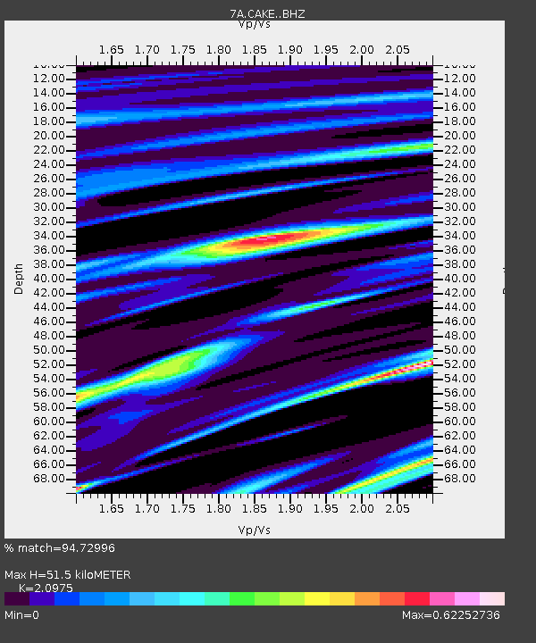
| Estimated Moho Depth: |
51.5 km |
| Estimated Crust Vp/Vs: |
2.10 |
| Assumed Crust Vp: |
6.159 km/s |
| Estimated Crust Vs: |
2.936 km/s |
| Estimated Crust Poisson's Ratio: |
0.35 |
|
| Radial Match: |
94.72996 % |
| Radial Bump: |
331 |
| Transverse Match: |
79.42743 % |
| Transverse Bump: |
400 |
| SOD ConfigId: |
7422571 |
| Insert Time: |
2019-04-22 18:53:31.982 +0000 |
| GWidth: |
2.5 |
| Max Bumps: |
400 |
| Tol: |
0.001 |
|

Signal To Noise
| Channel | StoN | STA | LTA |
| 7A:CAKE: :BHZ:20160607T10:57:17.284994Z | 16.780882 | 2.5252264E-6 | 1.5048234E-7 |
| 7A:CAKE: :BHN:20160607T10:57:17.284994Z | 6.521005 | 1.0118359E-6 | 1.5516564E-7 |
| 7A:CAKE: :BHE:20160607T10:57:17.284994Z | 12.788989 | 1.3926285E-6 | 1.0889278E-7 |
| Arrivals |
| Ps | 9.8 SECOND |
| PpPs | 24 SECOND |
| PsPs/PpSs | 34 SECOND |


