You are here: Home > Network List > 7A - Mid-Atlantic Geophysical Integrative Collaboration Stations List
> Station BARB Louisa, Virginia USA > Earthquake Result Viewer
BARB Louisa, Virginia USA - Earthquake Result Viewer
| Earthquake location: |
Off Coast Of Jalisco, Mexico |
| Earthquake latitude/longitude: |
18.4/-105.2 |
| Earthquake time(UTC): |
2016/06/07 (159) 10:51:38 GMT |
| Earthquake Depth: |
10 km |
| Earthquake Magnitude: |
6.2 MWP |
| Earthquake Catalog/Contributor: |
NEIC PDE/NEIC COMCAT |
|
| Network: |
7A Mid-Atlantic Geophysical Integrative Collaboration |
| Station: |
BARB Louisa, Virginia USA |
| Lat/Lon: |
37.99 N/78.09 W |
| Elevation: |
84 m |
|
| Distance: |
30.7 deg |
| Az: |
44.905 deg |
| Baz: |
238.025 deg |
| Ray Param: |
0.07927435 |
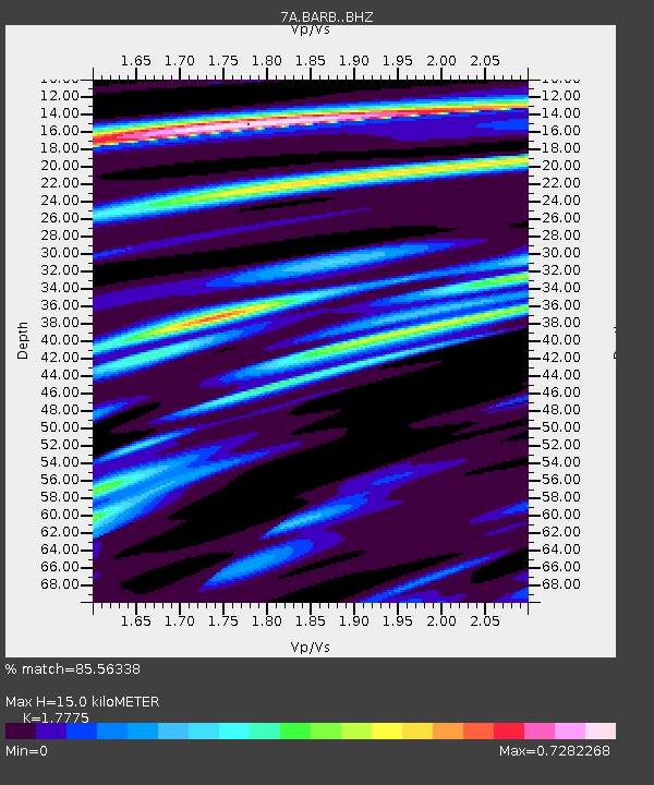
| Estimated Moho Depth: |
15.0 km |
| Estimated Crust Vp/Vs: |
1.78 |
| Assumed Crust Vp: |
6.419 km/s |
| Estimated Crust Vs: |
3.611 km/s |
| Estimated Crust Poisson's Ratio: |
0.27 |
|
| Radial Match: |
85.56338 % |
| Radial Bump: |
400 |
| Transverse Match: |
45.03096 % |
| Transverse Bump: |
400 |
| SOD ConfigId: |
7422571 |
| Insert Time: |
2019-04-22 18:53:32.645 +0000 |
| GWidth: |
2.5 |
| Max Bumps: |
400 |
| Tol: |
0.001 |
|

Signal To Noise
| Channel | StoN | STA | LTA |
| 7A:BARB: :BHZ:20160607T10:57:21.789999Z | 13.842228 | 1.969739E-6 | 1.4229929E-7 |
| 7A:BARB: :BHN:20160607T10:57:21.789999Z | 1.7469401 | 6.953512E-7 | 3.9803953E-7 |
| 7A:BARB: :BHE:20160607T10:57:21.789999Z | 2.2229383 | 1.8240404E-6 | 8.205538E-7 |
| Arrivals |
| Ps | 2.0 SECOND |
| PpPs | 6.0 SECOND |
| PsPs/PpSs | 8.0 SECOND |


