You are here: Home > Network List > 7A - Mid-Atlantic Geophysical Integrative Collaboration Stations List
> Station LADY Linville, Virginia USA > Earthquake Result Viewer
LADY Linville, Virginia USA - Earthquake Result Viewer
| Earthquake location: |
Off Coast Of Jalisco, Mexico |
| Earthquake latitude/longitude: |
18.4/-105.2 |
| Earthquake time(UTC): |
2016/06/07 (159) 10:51:38 GMT |
| Earthquake Depth: |
10 km |
| Earthquake Magnitude: |
6.2 MWP |
| Earthquake Catalog/Contributor: |
NEIC PDE/NEIC COMCAT |
|
| Network: |
7A Mid-Atlantic Geophysical Integrative Collaboration |
| Station: |
LADY Linville, Virginia USA |
| Lat/Lon: |
38.51 N/78.76 W |
| Elevation: |
401 m |
|
| Distance: |
30.5 deg |
| Az: |
43.485 deg |
| Baz: |
236.384 deg |
| Ray Param: |
0.07931929 |
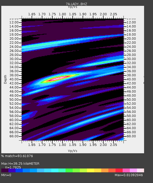
| Estimated Moho Depth: |
39.25 km |
| Estimated Crust Vp/Vs: |
1.78 |
| Assumed Crust Vp: |
6.159 km/s |
| Estimated Crust Vs: |
3.455 km/s |
| Estimated Crust Poisson's Ratio: |
0.27 |
|
| Radial Match: |
93.61876 % |
| Radial Bump: |
249 |
| Transverse Match: |
78.21872 % |
| Transverse Bump: |
400 |
| SOD ConfigId: |
7422571 |
| Insert Time: |
2019-04-22 18:53:37.339 +0000 |
| GWidth: |
2.5 |
| Max Bumps: |
400 |
| Tol: |
0.001 |
|

Signal To Noise
| Channel | StoN | STA | LTA |
| 7A:LADY: :BHZ:20160607T10:57:20.300009Z | 23.904333 | 2.4329265E-6 | 1.01777644E-7 |
| 7A:LADY: :BHN:20160607T10:57:20.300009Z | 7.3938026 | 9.2221967E-7 | 1.2472874E-7 |
| 7A:LADY: :BHE:20160607T10:57:20.300009Z | 14.001576 | 1.2697344E-6 | 9.0685106E-8 |
| Arrivals |
| Ps | 5.4 SECOND |
| PpPs | 16 SECOND |
| PsPs/PpSs | 22 SECOND |


