You are here: Home > Network List > 7A - Mid-Atlantic Geophysical Integrative Collaboration Stations List
> Station MOLE Hinton, Virginia USA > Earthquake Result Viewer
MOLE Hinton, Virginia USA - Earthquake Result Viewer
| Earthquake location: |
Off Coast Of Jalisco, Mexico |
| Earthquake latitude/longitude: |
18.4/-105.2 |
| Earthquake time(UTC): |
2016/06/07 (159) 10:51:38 GMT |
| Earthquake Depth: |
10 km |
| Earthquake Magnitude: |
6.2 MWP |
| Earthquake Catalog/Contributor: |
NEIC PDE/NEIC COMCAT |
|
| Network: |
7A Mid-Atlantic Geophysical Integrative Collaboration |
| Station: |
MOLE Hinton, Virginia USA |
| Lat/Lon: |
38.49 N/79.02 W |
| Elevation: |
487 m |
|
| Distance: |
30.3 deg |
| Az: |
43.291 deg |
| Baz: |
236.061 deg |
| Ray Param: |
0.07936472 |
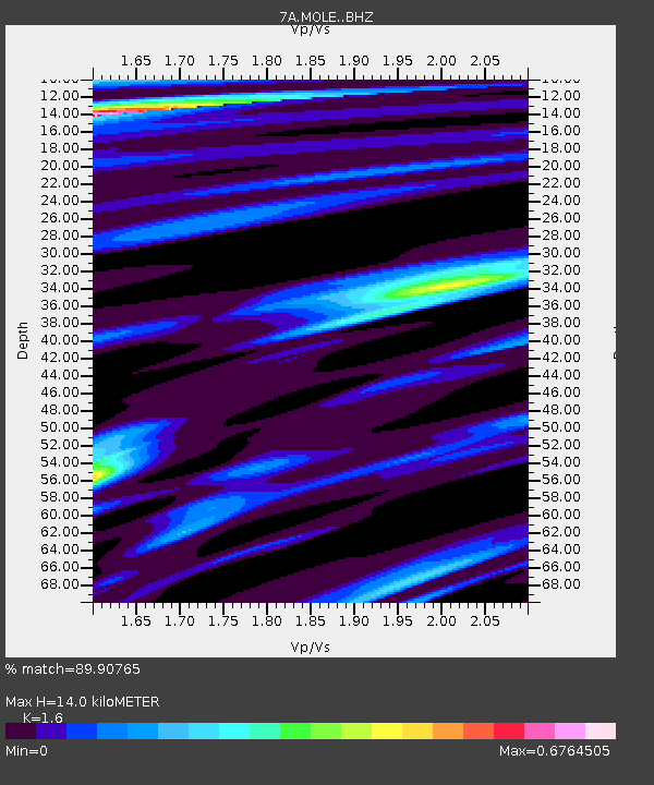
| Estimated Moho Depth: |
14.0 km |
| Estimated Crust Vp/Vs: |
1.60 |
| Assumed Crust Vp: |
6.159 km/s |
| Estimated Crust Vs: |
3.849 km/s |
| Estimated Crust Poisson's Ratio: |
0.18 |
|
| Radial Match: |
89.90765 % |
| Radial Bump: |
235 |
| Transverse Match: |
80.38638 % |
| Transverse Bump: |
400 |
| SOD ConfigId: |
7422571 |
| Insert Time: |
2019-04-22 18:53:37.835 +0000 |
| GWidth: |
2.5 |
| Max Bumps: |
400 |
| Tol: |
0.001 |
|

Signal To Noise
| Channel | StoN | STA | LTA |
| 7A:MOLE: :BHZ:20160607T10:57:18.775015Z | 20.813694 | 3.0507995E-6 | 1.4657655E-7 |
| 7A:MOLE: :BHN:20160607T10:57:18.775015Z | 7.687657 | 9.635735E-7 | 1.2534034E-7 |
| 7A:MOLE: :BHE:20160607T10:57:18.775015Z | 13.179476 | 1.518778E-6 | 1.1523812E-7 |
| Arrivals |
| Ps | 1.5 SECOND |
| PpPs | 5.4 SECOND |
| PsPs/PpSs | 6.9 SECOND |


