You are here: Home > Network List > AK - Alaska Regional Network Stations List
> Station CHUM Lake Minchumina Broadband > Earthquake Result Viewer
CHUM Lake Minchumina Broadband - Earthquake Result Viewer
| Earthquake location: |
Off Coast Of Jalisco, Mexico |
| Earthquake latitude/longitude: |
18.4/-105.2 |
| Earthquake time(UTC): |
2016/06/07 (159) 10:51:38 GMT |
| Earthquake Depth: |
10 km |
| Earthquake Magnitude: |
6.2 MWP |
| Earthquake Catalog/Contributor: |
NEIC PDE/NEIC COMCAT |
|
| Network: |
AK Alaska Regional Network |
| Station: |
CHUM Lake Minchumina Broadband |
| Lat/Lon: |
63.88 N/152.31 W |
| Elevation: |
58 m |
|
| Distance: |
55.4 deg |
| Az: |
336.801 deg |
| Baz: |
122.325 deg |
| Ray Param: |
0.0647992 |
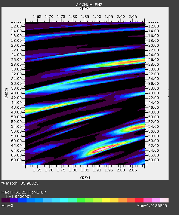
| Estimated Moho Depth: |
63.25 km |
| Estimated Crust Vp/Vs: |
1.92 |
| Assumed Crust Vp: |
6.566 km/s |
| Estimated Crust Vs: |
3.42 km/s |
| Estimated Crust Poisson's Ratio: |
0.31 |
|
| Radial Match: |
85.98323 % |
| Radial Bump: |
400 |
| Transverse Match: |
73.36492 % |
| Transverse Bump: |
400 |
| SOD ConfigId: |
7422571 |
| Insert Time: |
2019-04-22 18:54:09.660 +0000 |
| GWidth: |
2.5 |
| Max Bumps: |
400 |
| Tol: |
0.001 |
|

Signal To Noise
| Channel | StoN | STA | LTA |
| AK:CHUM: :BHZ:20160607T11:00:41.548025Z | 12.046974 | 8.0511103E-7 | 6.683097E-8 |
| AK:CHUM: :BHN:20160607T11:00:41.548025Z | 2.946853 | 2.2936736E-7 | 7.783468E-8 |
| AK:CHUM: :BHE:20160607T11:00:41.548025Z | 5.9766946 | 3.274332E-7 | 5.4785E-8 |
| Arrivals |
| Ps | 9.3 SECOND |
| PpPs | 27 SECOND |
| PsPs/PpSs | 36 SECOND |


