You are here: Home > Network List > AK - Alaska Regional Network Stations List
> Station GLB Gilahina Butte, AK, USA > Earthquake Result Viewer
GLB Gilahina Butte, AK, USA - Earthquake Result Viewer
| Earthquake location: |
Off Coast Of Jalisco, Mexico |
| Earthquake latitude/longitude: |
18.4/-105.2 |
| Earthquake time(UTC): |
2016/06/07 (159) 10:51:38 GMT |
| Earthquake Depth: |
10 km |
| Earthquake Magnitude: |
6.2 MWP |
| Earthquake Catalog/Contributor: |
NEIC PDE/NEIC COMCAT |
|
| Network: |
AK Alaska Regional Network |
| Station: |
GLB Gilahina Butte, AK, USA |
| Lat/Lon: |
61.44 N/143.81 W |
| Elevation: |
855 m |
|
| Distance: |
50.8 deg |
| Az: |
337.235 deg |
| Baz: |
130.132 deg |
| Ray Param: |
0.06780007 |
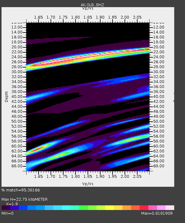
| Estimated Moho Depth: |
22.75 km |
| Estimated Crust Vp/Vs: |
1.90 |
| Assumed Crust Vp: |
6.566 km/s |
| Estimated Crust Vs: |
3.456 km/s |
| Estimated Crust Poisson's Ratio: |
0.31 |
|
| Radial Match: |
95.38166 % |
| Radial Bump: |
244 |
| Transverse Match: |
85.666695 % |
| Transverse Bump: |
400 |
| SOD ConfigId: |
7422571 |
| Insert Time: |
2019-04-22 18:54:18.795 +0000 |
| GWidth: |
2.5 |
| Max Bumps: |
400 |
| Tol: |
0.001 |
|

Signal To Noise
| Channel | StoN | STA | LTA |
| AK:GLB: :BHZ:20160607T11:00:07.66799Z | 15.147644 | 7.832052E-7 | 5.1704756E-8 |
| AK:GLB: :BHN:20160607T11:00:07.66799Z | 7.2283573 | 3.5368566E-7 | 4.8930296E-8 |
| AK:GLB: :BHE:20160607T11:00:07.66799Z | 6.7330275 | 3.4381696E-7 | 5.1064244E-8 |
| Arrivals |
| Ps | 3.3 SECOND |
| PpPs | 9.5 SECOND |
| PsPs/PpSs | 13 SECOND |


