You are here: Home > Network List > AK - Alaska Regional Network Stations List
> Station ISLE Juniper Island, AK, USA > Earthquake Result Viewer
ISLE Juniper Island, AK, USA - Earthquake Result Viewer
| Earthquake location: |
Off Coast Of Jalisco, Mexico |
| Earthquake latitude/longitude: |
18.4/-105.2 |
| Earthquake time(UTC): |
2016/06/07 (159) 10:51:38 GMT |
| Earthquake Depth: |
10 km |
| Earthquake Magnitude: |
6.2 MWP |
| Earthquake Catalog/Contributor: |
NEIC PDE/NEIC COMCAT |
|
| Network: |
AK Alaska Regional Network |
| Station: |
ISLE Juniper Island, AK, USA |
| Lat/Lon: |
60.60 N/142.34 W |
| Elevation: |
1485 m |
|
| Distance: |
49.7 deg |
| Az: |
337.012 deg |
| Baz: |
131.275 deg |
| Ray Param: |
0.0685165 |
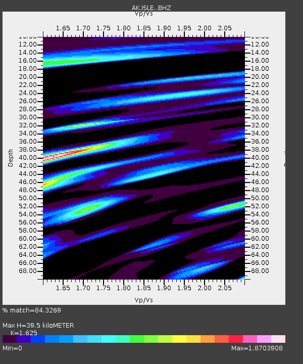
| Estimated Moho Depth: |
39.5 km |
| Estimated Crust Vp/Vs: |
1.62 |
| Assumed Crust Vp: |
6.566 km/s |
| Estimated Crust Vs: |
4.041 km/s |
| Estimated Crust Poisson's Ratio: |
0.20 |
|
| Radial Match: |
84.3269 % |
| Radial Bump: |
400 |
| Transverse Match: |
77.647514 % |
| Transverse Bump: |
400 |
| SOD ConfigId: |
7422571 |
| Insert Time: |
2019-04-22 18:54:27.407 +0000 |
| GWidth: |
2.5 |
| Max Bumps: |
400 |
| Tol: |
0.001 |
|

Signal To Noise
| Channel | StoN | STA | LTA |
| AK:ISLE: :BHZ:20160607T10:59:59.40801Z | 7.2450256 | 7.715871E-7 | 1.0649888E-7 |
| AK:ISLE: :BHN:20160607T10:59:59.40801Z | 1.2134074 | 2.6502403E-7 | 2.1841308E-7 |
| AK:ISLE: :BHE:20160607T10:59:59.40801Z | 2.6745985 | 5.1828204E-7 | 1.937794E-7 |
| Arrivals |
| Ps | 4.0 SECOND |
| PpPs | 15 SECOND |
| PsPs/PpSs | 19 SECOND |


