You are here: Home > Network List > AK - Alaska Regional Network Stations List
> Station MCAR McCarthy VSAT, AK, USA > Earthquake Result Viewer
MCAR McCarthy VSAT, AK, USA - Earthquake Result Viewer
| Earthquake location: |
Off Coast Of Jalisco, Mexico |
| Earthquake latitude/longitude: |
18.4/-105.2 |
| Earthquake time(UTC): |
2016/06/07 (159) 10:51:38 GMT |
| Earthquake Depth: |
10 km |
| Earthquake Magnitude: |
6.2 MWP |
| Earthquake Catalog/Contributor: |
NEIC PDE/NEIC COMCAT |
|
| Network: |
AK Alaska Regional Network |
| Station: |
MCAR McCarthy VSAT, AK, USA |
| Lat/Lon: |
61.38 N/143.02 W |
| Elevation: |
447 m |
|
| Distance: |
50.5 deg |
| Az: |
337.496 deg |
| Baz: |
130.989 deg |
| Ray Param: |
0.06801997 |
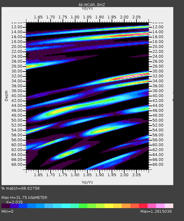
| Estimated Moho Depth: |
31.75 km |
| Estimated Crust Vp/Vs: |
2.04 |
| Assumed Crust Vp: |
6.566 km/s |
| Estimated Crust Vs: |
3.227 km/s |
| Estimated Crust Poisson's Ratio: |
0.34 |
|
| Radial Match: |
89.82759 % |
| Radial Bump: |
400 |
| Transverse Match: |
87.07949 % |
| Transverse Bump: |
400 |
| SOD ConfigId: |
7422571 |
| Insert Time: |
2019-04-22 18:54:32.960 +0000 |
| GWidth: |
2.5 |
| Max Bumps: |
400 |
| Tol: |
0.001 |
|

Signal To Noise
| Channel | StoN | STA | LTA |
| AK:MCAR: :BHZ:20160607T11:00:05.207998Z | 9.6168 | 7.618175E-7 | 7.921736E-8 |
| AK:MCAR: :BHN:20160607T11:00:05.207998Z | 4.140927 | 3.482702E-7 | 8.4104414E-8 |
| AK:MCAR: :BHE:20160607T11:00:05.207998Z | 3.566301 | 2.4914107E-7 | 6.98598E-8 |
| Arrivals |
| Ps | 5.3 SECOND |
| PpPs | 14 SECOND |
| PsPs/PpSs | 19 SECOND |


