You are here: Home > Network List > N4 - Central and EAstern US Network Stations List
> Station N35B Tabor, IA, USA > Earthquake Result Viewer
N35B Tabor, IA, USA - Earthquake Result Viewer
| Earthquake location: |
Off Coast Of Ecuador |
| Earthquake latitude/longitude: |
1.1/-85.2 |
| Earthquake time(UTC): |
2015/08/07 (219) 12:18:48 GMT |
| Earthquake Depth: |
10 km |
| Earthquake Magnitude: |
5.6 MWW, 5.6 MWC, 5.6 MWB |
| Earthquake Catalog/Contributor: |
NEIC PDE/NEIC COMCAT |
|
| Network: |
N4 Central and EAstern US Network |
| Station: |
N35B Tabor, IA, USA |
| Lat/Lon: |
40.86 N/95.64 W |
| Elevation: |
353 m |
|
| Distance: |
40.7 deg |
| Az: |
347.801 deg |
| Baz: |
163.826 deg |
| Ray Param: |
0.07424135 |
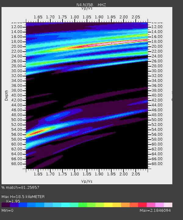
| Estimated Moho Depth: |
18.5 km |
| Estimated Crust Vp/Vs: |
1.95 |
| Assumed Crust Vp: |
6.498 km/s |
| Estimated Crust Vs: |
3.332 km/s |
| Estimated Crust Poisson's Ratio: |
0.32 |
|
| Radial Match: |
81.25957 % |
| Radial Bump: |
400 |
| Transverse Match: |
60.47233 % |
| Transverse Bump: |
400 |
| SOD ConfigId: |
1156111 |
| Insert Time: |
2015-09-17 14:29:11.312 +0000 |
| GWidth: |
2.5 |
| Max Bumps: |
400 |
| Tol: |
0.001 |
|

Signal To Noise
| Channel | StoN | STA | LTA |
| N4:N35B: :HHZ:20150807T12:25:58.389987Z | 3.8388374 | 4.7037187E-7 | 1.2252977E-7 |
| N4:N35B: :HHN:20150807T12:25:58.389987Z | 1.8491578 | 3.4329977E-7 | 1.8565197E-7 |
| N4:N35B: :HHE:20150807T12:25:58.389987Z | 1.5889939 | 2.499443E-7 | 1.5729721E-7 |
| Arrivals |
| Ps | 2.9 SECOND |
| PpPs | 7.9 SECOND |
| PsPs/PpSs | 11 SECOND |


