You are here: Home > Network List > US - United States National Seismic Network Stations List
> Station WVOR Wild Horse Valley, Oregon, USA > Earthquake Result Viewer
WVOR Wild Horse Valley, Oregon, USA - Earthquake Result Viewer
| Earthquake location: |
Solomon Islands |
| Earthquake latitude/longitude: |
-8.5/157.0 |
| Earthquake time(UTC): |
2007/04/01 (091) 20:39:56 GMT |
| Earthquake Depth: |
10 km |
| Earthquake Magnitude: |
6.8 MB, 7.9 MS, 8.1 MW, 7.7 ME |
| Earthquake Catalog/Contributor: |
WHDF/NEIC |
|
| Network: |
US United States National Seismic Network |
| Station: |
WVOR Wild Horse Valley, Oregon, USA |
| Lat/Lon: |
42.43 N/118.64 W |
| Elevation: |
1344 m |
|
| Distance: |
91.5 deg |
| Az: |
47.469 deg |
| Baz: |
259.974 deg |
| Ray Param: |
0.041599322 |
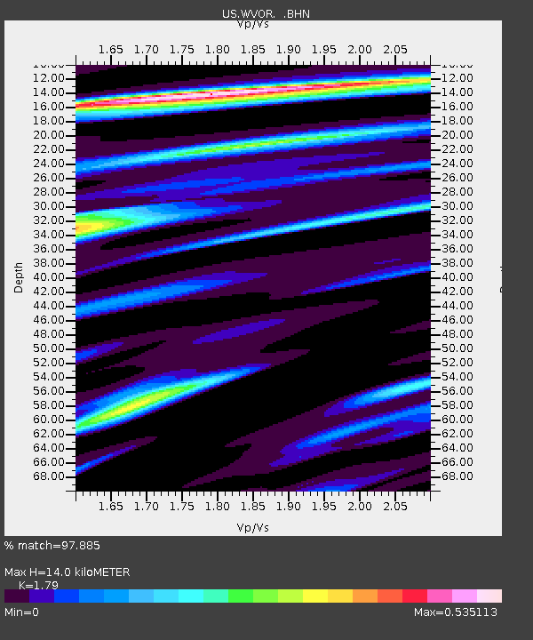
| Estimated Moho Depth: |
14.0 km |
| Estimated Crust Vp/Vs: |
1.79 |
| Assumed Crust Vp: |
6.279 km/s |
| Estimated Crust Vs: |
3.508 km/s |
| Estimated Crust Poisson's Ratio: |
0.27 |
|
| Radial Match: |
97.885 % |
| Radial Bump: |
400 |
| Transverse Match: |
92.59633 % |
| Transverse Bump: |
400 |
| SOD ConfigId: |
2564 |
| Insert Time: |
2010-03-05 04:21:42.771 +0000 |
| GWidth: |
2.5 |
| Max Bumps: |
400 |
| Tol: |
0.001 |
|
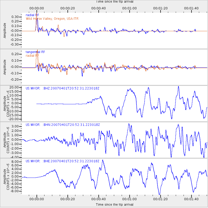
Signal To Noise
| Channel | StoN | STA | LTA |
| US:WVOR: :BHN:20070401T20:52:31.223018Z | 1.1990428 | 1.3410151E-7 | 1.1184048E-7 |
| US:WVOR: :BHE:20070401T20:52:31.223018Z | 2.338885 | 3.5661998E-7 | 1.5247436E-7 |
| US:WVOR: :BHZ:20070401T20:52:31.223018Z | 10.326935 | 1.3916284E-6 | 1.3475717E-7 |
| Arrivals |
| Ps | 1.8 SECOND |
| PpPs | 6.1 SECOND |
| PsPs/PpSs | 7.9 SECOND |


