You are here: Home > Network List > CN - Canadian National Seismograph Network Stations List
> Station WALA Waterton Lake, AB, CA > Earthquake Result Viewer
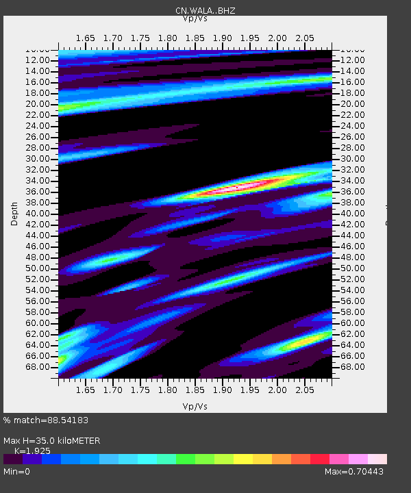
WALA Waterton Lake, AB, CA - Earthquake Result Viewer
| Earthquake location: |
Off Coast Of Jalisco, Mexico |
| Earthquake latitude/longitude: |
18.4/-105.2 |
| Earthquake time(UTC): |
2016/06/07 (159) 10:51:38 GMT |
| Earthquake Depth: |
10 km |
| Earthquake Magnitude: |
6.2 MWP |
| Earthquake Catalog/Contributor: |
NEIC PDE/NEIC COMCAT |
|
| Network: |
CN Canadian National Seismograph Network |
| Station: |
WALA Waterton Lake, AB, CA |
| Lat/Lon: |
49.06 N/113.91 W |
| Elevation: |
1400 m |
|
| Distance: |
31.4 deg |
| Az: |
348.953 deg |
| Baz: |
163.944 deg |
| Ray Param: |
0.07908564 |
| Estimated Moho Depth: |
35.0 km |
| Estimated Crust Vp/Vs: |
1.92 |
| Assumed Crust Vp: |
6.178 km/s |
| Estimated Crust Vs: |
3.209 km/s |
| Estimated Crust Poisson's Ratio: |
0.32 |
|
| Radial Match: |
88.54183 % |
| Radial Bump: |
385 |
| Transverse Match: |
71.23281 % |
| Transverse Bump: |
400 |
| SOD ConfigId: |
7422571 |
| Insert Time: |
2019-04-22 18:56:51.005 +0000 |
| GWidth: |
2.5 |
| Max Bumps: |
400 |
| Tol: |
0.001 |
|

Signal To Noise
| Channel | StoN | STA | LTA |
| CN:WALA: :BHZ:20160607T10:57:28.325002Z | 8.444413 | 1.0082366E-6 | 1.1939689E-7 |
| CN:WALA: :BHN:20160607T10:57:28.325002Z | 6.246125 | 4.5946422E-7 | 7.3559875E-8 |
| CN:WALA: :BHE:20160607T10:57:28.325002Z | 1.9891218 | 3.1533355E-7 | 1.5852903E-7 |
| Arrivals |
| Ps | 5.6 SECOND |
| PpPs | 15 SECOND |
| PsPs/PpSs | 21 SECOND |


