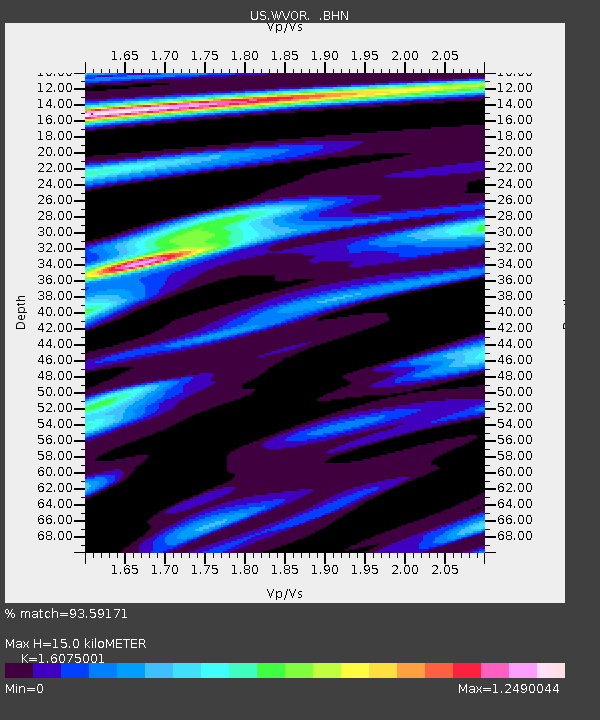
WVOR Wild Horse Valley, Oregon, USA - Earthquake Result Viewer
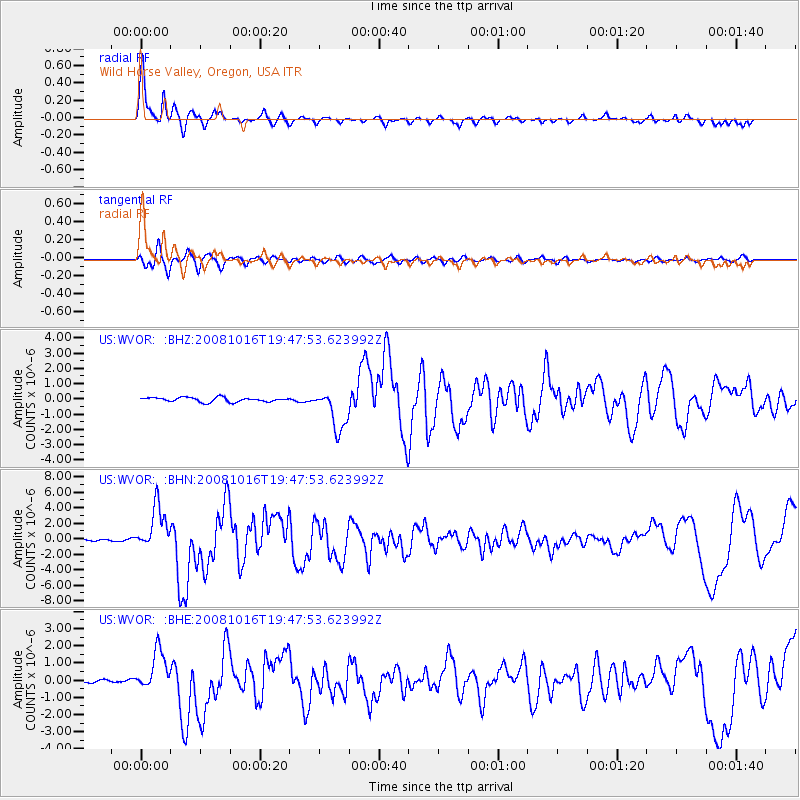
Earthquake location: Near Coast Of Chiapas, Mexico
Earthquake latitude/longitude: 14.4/-92.4
Earthquake time(UTC): 2008/10/16 (290) 19:41:25 GMT
Earthquake Depth: 24 km
Earthquake Magnitude: 6.1 MB, 6.6 MS, 6.7 MW, 6.6 MW
Earthquake Catalog/Contributor: WHDF/NEIC
Network: US United States National Seismic Network
Station: WVOR Wild Horse Valley, Oregon, USA
Lat/Lon: 42.43 N/118.64 W
Elevation: 1344 m
Distance: 35.9 deg
Az: 326.066 deg
Baz: 133.064 deg
Ray Param: 0.076912776
Estimated Moho Depth: 15.0 km
Estimated Crust Vp/Vs: 1.61
Assumed Crust Vp: 6.279 km/s
Estimated Crust Vs: 3.906 km/s
Estimated Crust Poisson's Ratio: 0.18
Radial Match: 93.59171 %
Radial Bump: 391
Transverse Match: 83.42149 %
Transverse Bump: 400
SOD ConfigId: 2556
Insert Time: 2010-03-05 04:22:22.916 +0000
GWidth: 2.5
Max Bumps: 400
Tol: 0.001

Signal To Noise

ChannelStoNSTALTA
US:WVOR: :BHN:20081016T19:47:53.623992Z30.156642.8417612E-69.423335E-8
US:WVOR: :BHE:20081016T19:47:53.623992Z9.2120651.1575163E-61.256522E-7
US:WVOR: :BHZ:20081016T19:47:53.623992Z9.42371.3517653E-61.4344316E-7
Arrivals
Ps1.6 SECOND
PpPs5.8 SECOND
PsPs/PpSs7.3 SECOND