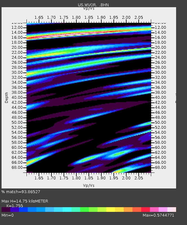
WVOR Wild Horse Valley, Oregon, USA - Earthquake Result Viewer
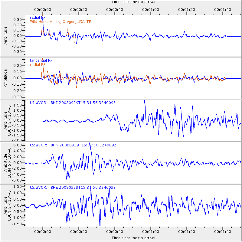
Earthquake location: Kermadec Islands, New Zealand
Earthquake latitude/longitude: -29.8/-177.7
Earthquake time(UTC): 2008/09/29 (273) 15:19:31 GMT
Earthquake Depth: 36 km
Earthquake Magnitude: 6.5 MB, 6.7 MS, 7.0 MW, 7.0 MW
Earthquake Catalog/Contributor: WHDF/NEIC
Network: US United States National Seismic Network
Station: WVOR Wild Horse Valley, Oregon, USA
Lat/Lon: 42.43 N/118.64 W
Elevation: 1344 m
Distance: 90.0 deg
Az: 39.411 deg
Baz: 228.222 deg
Ray Param: 0.041696563
Estimated Moho Depth: 14.75 km
Estimated Crust Vp/Vs: 1.75
Assumed Crust Vp: 6.279 km/s
Estimated Crust Vs: 3.578 km/s
Estimated Crust Poisson's Ratio: 0.26
Radial Match: 93.86527 %
Radial Bump: 400
Transverse Match: 88.63147 %
Transverse Bump: 400
SOD ConfigId: 2560
Insert Time: 2010-03-05 04:22:28.515 +0000
GWidth: 2.5
Max Bumps: 400
Tol: 0.001

Signal To Noise

ChannelStoNSTALTA
US:WVOR: :BHN:20080929T15:31:56.324009Z8.1168686.0495313E-77.453036E-8
US:WVOR: :BHE:20080929T15:31:56.324009Z1.64365911.2541054E-77.62996E-8
US:WVOR: :BHZ:20080929T15:31:56.324009Z2.12303881.4651492E-76.90119E-8
Arrivals
Ps1.8 SECOND
PpPs6.3 SECOND
PsPs/PpSs8.2 SECOND