You are here: Home > Network List > US - United States National Seismic Network Stations List
> Station WVOR Wild Horse Valley, Oregon, USA > Earthquake Result Viewer
WVOR Wild Horse Valley, Oregon, USA - Earthquake Result Viewer

| Earthquake location: |
Santa Cruz Islands Region |
| Earthquake latitude/longitude: |
-11.0/164.5 |
| Earthquake time(UTC): |
2008/07/19 (201) 09:27:01 GMT |
| Earthquake Depth: |
11 km |
| Earthquake Magnitude: |
6.1 MB, 6.4 MS, 6.6 MW, 6.6 MW |
| Earthquake Catalog/Contributor: |
WHDF/NEIC |
|
| Network: |
US United States National Seismic Network |
| Station: |
WVOR Wild Horse Valley, Oregon, USA |
| Lat/Lon: |
42.43 N/118.64 W |
| Elevation: |
1344 m |
|
| Distance: |
87.9 deg |
| Az: |
46.175 deg |
| Baz: |
253.083 deg |
| Ray Param: |
0.043007534 |
| Estimated Moho Depth: |
24.0 km |
| Estimated Crust Vp/Vs: |
1.60 |
| Assumed Crust Vp: |
6.279 km/s |
| Estimated Crust Vs: |
3.924 km/s |
| Estimated Crust Poisson's Ratio: |
0.18 |
|
| Radial Match: |
93.820145 % |
| Radial Bump: |
400 |
| Transverse Match: |
81.976234 % |
| Transverse Bump: |
400 |
| SOD ConfigId: |
2658 |
| Insert Time: |
2010-03-05 04:22:35.899 +0000 |
| GWidth: |
2.5 |
| Max Bumps: |
400 |
| Tol: |
0.001 |
|
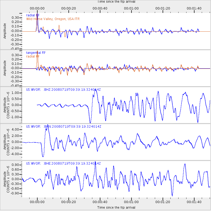
Signal To Noise
| Channel | StoN | STA | LTA |
| US:WVOR: :BHN:20080719T09:39:19.324014Z | 52.077366 | 2.1686828E-6 | 4.1643478E-8 |
| US:WVOR: :BHE:20080719T09:39:19.324014Z | 2.8122818 | 1.9182897E-7 | 6.821115E-8 |
| US:WVOR: :BHZ:20080719T09:39:19.324014Z | 9.014543 | 6.620924E-7 | 7.344715E-8 |
| Arrivals |
| Ps | 2.3 SECOND |
| PpPs | 9.7 SECOND |
| PsPs/PpSs | 12 SECOND |


