You are here: Home > Network List > N4 - Central and EAstern US Network Stations List
> Station J61A Chester > Earthquake Result Viewer
J61A Chester - Earthquake Result Viewer
| Earthquake location: |
Off Coast Of Jalisco, Mexico |
| Earthquake latitude/longitude: |
18.4/-105.2 |
| Earthquake time(UTC): |
2016/06/07 (159) 10:51:38 GMT |
| Earthquake Depth: |
10 km |
| Earthquake Magnitude: |
6.2 MWP |
| Earthquake Catalog/Contributor: |
NEIC PDE/NEIC COMCAT |
|
| Network: |
N4 Central and EAstern US Network |
| Station: |
J61A Chester |
| Lat/Lon: |
43.35 N/72.55 W |
| Elevation: |
253 m |
|
| Distance: |
37.1 deg |
| Az: |
40.754 deg |
| Baz: |
238.169 deg |
| Ray Param: |
0.076342374 |
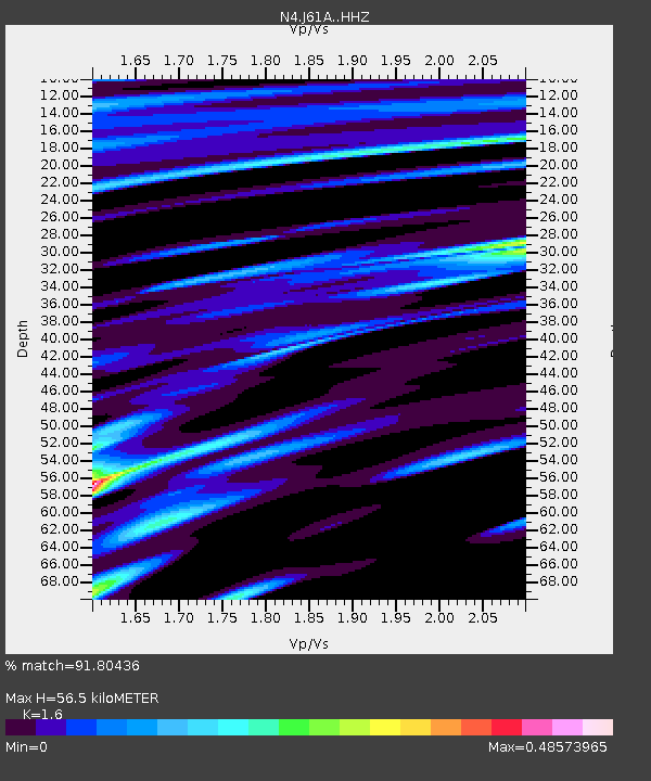
| Estimated Moho Depth: |
56.5 km |
| Estimated Crust Vp/Vs: |
1.60 |
| Assumed Crust Vp: |
6.419 km/s |
| Estimated Crust Vs: |
4.012 km/s |
| Estimated Crust Poisson's Ratio: |
0.18 |
|
| Radial Match: |
91.80436 % |
| Radial Bump: |
256 |
| Transverse Match: |
83.20191 % |
| Transverse Bump: |
400 |
| SOD ConfigId: |
7422571 |
| Insert Time: |
2019-04-22 18:59:16.049 +0000 |
| GWidth: |
2.5 |
| Max Bumps: |
400 |
| Tol: |
0.001 |
|

Signal To Noise
| Channel | StoN | STA | LTA |
| N4:J61A: :HHZ:20160607T10:58:17.240011Z | 9.726502 | 2.8980187E-6 | 2.9795075E-7 |
| N4:J61A: :HHN:20160607T10:58:17.240011Z | 8.838732 | 1.144548E-6 | 1.2949234E-7 |
| N4:J61A: :HHE:20160607T10:58:17.240011Z | 6.691364 | 1.4881E-6 | 2.2239115E-7 |
| Arrivals |
| Ps | 5.7 SECOND |
| PpPs | 21 SECOND |
| PsPs/PpSs | 27 SECOND |


