You are here: Home > Network List > US - United States National Seismic Network Stations List
> Station WVOR Wild Horse Valley, Oregon, USA > Earthquake Result Viewer
WVOR Wild Horse Valley, Oregon, USA - Earthquake Result Viewer
| Earthquake location: |
Peru-Ecuador Border Region |
| Earthquake latitude/longitude: |
-2.8/-77.9 |
| Earthquake time(UTC): |
1995/10/03 (276) 01:51:24 GMT |
| Earthquake Depth: |
27 km |
| Earthquake Magnitude: |
6.5 MB, 7.0 MS, 6.9 UNKNOWN, 7.0 MW |
| Earthquake Catalog/Contributor: |
WHDF/NEIC |
|
| Network: |
US United States National Seismic Network |
| Station: |
WVOR Wild Horse Valley, Oregon, USA |
| Lat/Lon: |
42.43 N/118.64 W |
| Elevation: |
1344 m |
|
| Distance: |
58.1 deg |
| Az: |
325.32 deg |
| Baz: |
129.852 deg |
| Ray Param: |
0.06299686 |
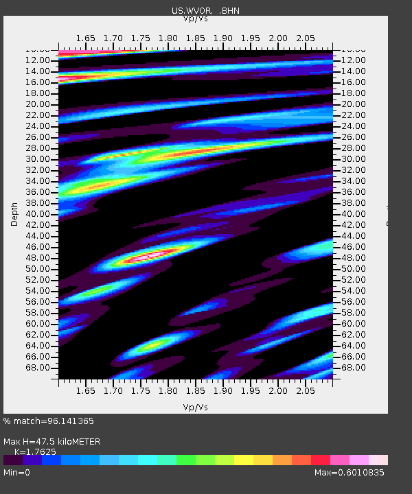
| Estimated Moho Depth: |
47.5 km |
| Estimated Crust Vp/Vs: |
1.76 |
| Assumed Crust Vp: |
6.279 km/s |
| Estimated Crust Vs: |
3.562 km/s |
| Estimated Crust Poisson's Ratio: |
0.26 |
|
| Radial Match: |
96.141365 % |
| Radial Bump: |
400 |
| Transverse Match: |
92.8421 % |
| Transverse Bump: |
400 |
| SOD ConfigId: |
110177 |
| Insert Time: |
2010-03-05 04:22:50.500 +0000 |
| GWidth: |
2.5 |
| Max Bumps: |
400 |
| Tol: |
0.001 |
|
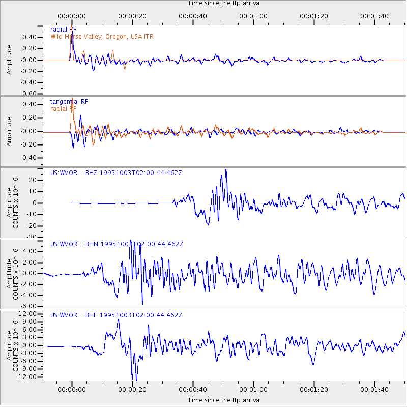
Signal To Noise
| Channel | StoN | STA | LTA |
| US:WVOR: :BHN:19951003T02:00:44.462Z | 1.0417469 | 1.4527019E-7 | 1.3944864E-7 |
| US:WVOR: :BHE:19951003T02:00:44.462Z | 1.9145161 | 3.197617E-7 | 1.6701959E-7 |
| US:WVOR: :BHZ:19951003T02:00:44.462Z | 7.7748313 | 9.411162E-7 | 1.210465E-7 |
| Arrivals |
| Ps | 6.0 SECOND |
| PpPs | 20 SECOND |
| PsPs/PpSs | 26 SECOND |


