You are here: Home > Network List > N4 - Central and EAstern US Network Stations List
> Station P61A Hammonton, NJ, USA > Earthquake Result Viewer
P61A Hammonton, NJ, USA - Earthquake Result Viewer
| Earthquake location: |
Off Coast Of Jalisco, Mexico |
| Earthquake latitude/longitude: |
18.4/-105.2 |
| Earthquake time(UTC): |
2016/06/07 (159) 10:51:38 GMT |
| Earthquake Depth: |
10 km |
| Earthquake Magnitude: |
6.2 MWP |
| Earthquake Catalog/Contributor: |
NEIC PDE/NEIC COMCAT |
|
| Network: |
N4 Central and EAstern US Network |
| Station: |
P61A Hammonton, NJ, USA |
| Lat/Lon: |
39.67 N/74.79 W |
| Elevation: |
22 m |
|
| Distance: |
33.7 deg |
| Az: |
44.693 deg |
| Baz: |
239.903 deg |
| Ray Param: |
0.07807417 |
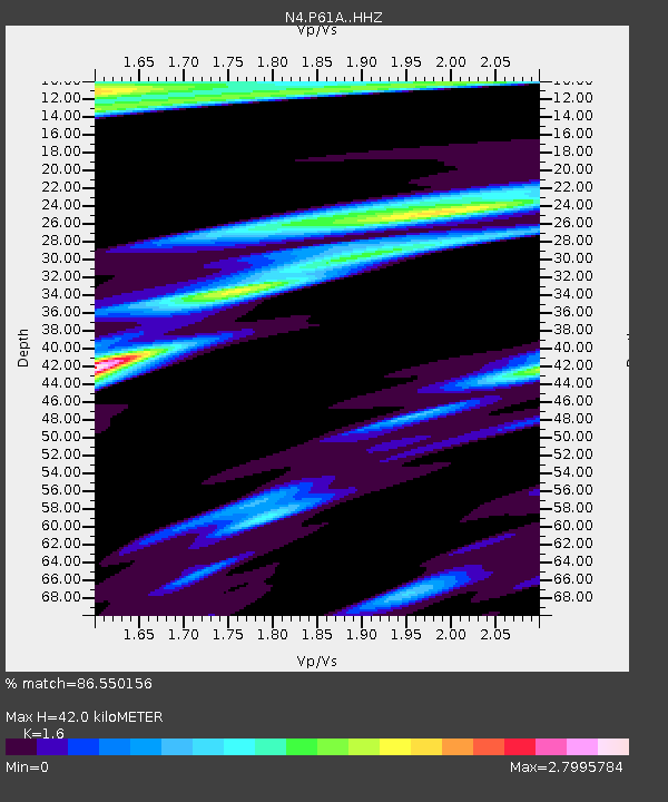
| Estimated Moho Depth: |
42.0 km |
| Estimated Crust Vp/Vs: |
1.60 |
| Assumed Crust Vp: |
6.287 km/s |
| Estimated Crust Vs: |
3.93 km/s |
| Estimated Crust Poisson's Ratio: |
0.18 |
|
| Radial Match: |
86.550156 % |
| Radial Bump: |
327 |
| Transverse Match: |
75.39106 % |
| Transverse Bump: |
342 |
| SOD ConfigId: |
7422571 |
| Insert Time: |
2019-04-22 18:59:33.139 +0000 |
| GWidth: |
2.5 |
| Max Bumps: |
400 |
| Tol: |
0.001 |
|

Signal To Noise
| Channel | StoN | STA | LTA |
| N4:P61A: :HHZ:20160607T10:57:48.629995Z | 7.812643 | 3.6422057E-6 | 4.6619377E-7 |
| N4:P61A: :HHN:20160607T10:57:48.629995Z | 2.6815672 | 2.0082284E-6 | 7.48901E-7 |
| N4:P61A: :HHE:20160607T10:57:48.629995Z | 3.0085847 | 3.1146317E-6 | 1.0352481E-6 |
| Arrivals |
| Ps | 4.4 SECOND |
| PpPs | 16 SECOND |
| PsPs/PpSs | 20 SECOND |


