You are here: Home > Network List > N4 - Central and EAstern US Network Stations List
> Station V61A Roper, NC, USA > Earthquake Result Viewer
V61A Roper, NC, USA - Earthquake Result Viewer
| Earthquake location: |
Off Coast Of Jalisco, Mexico |
| Earthquake latitude/longitude: |
18.4/-105.2 |
| Earthquake time(UTC): |
2016/06/07 (159) 10:51:38 GMT |
| Earthquake Depth: |
10 km |
| Earthquake Magnitude: |
6.2 MWP |
| Earthquake Catalog/Contributor: |
NEIC PDE/NEIC COMCAT |
|
| Network: |
N4 Central and EAstern US Network |
| Station: |
V61A Roper, NC, USA |
| Lat/Lon: |
35.79 N/76.58 W |
| Elevation: |
4.0 m |
|
| Distance: |
30.6 deg |
| Az: |
49.822 deg |
| Baz: |
243.158 deg |
| Ray Param: |
0.0792809 |
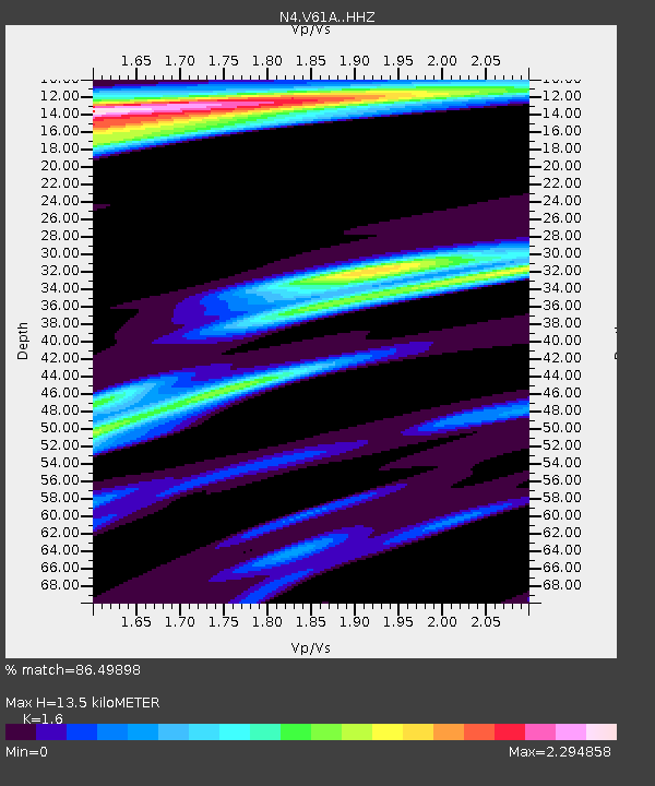
| Estimated Moho Depth: |
13.5 km |
| Estimated Crust Vp/Vs: |
1.60 |
| Assumed Crust Vp: |
6.565 km/s |
| Estimated Crust Vs: |
4.103 km/s |
| Estimated Crust Poisson's Ratio: |
0.18 |
|
| Radial Match: |
86.49898 % |
| Radial Bump: |
366 |
| Transverse Match: |
63.413185 % |
| Transverse Bump: |
369 |
| SOD ConfigId: |
7422571 |
| Insert Time: |
2019-04-22 18:59:37.969 +0000 |
| GWidth: |
2.5 |
| Max Bumps: |
400 |
| Tol: |
0.001 |
|

Signal To Noise
| Channel | StoN | STA | LTA |
| N4:V61A: :HHZ:20160607T10:57:21.529989Z | 8.438469 | 3.2051823E-6 | 3.7982988E-7 |
| N4:V61A: :HHN:20160607T10:57:21.529989Z | 1.5545448 | 1.4899289E-6 | 9.584343E-7 |
| N4:V61A: :HHE:20160607T10:57:21.529989Z | 2.9658637 | 2.1353546E-6 | 7.199774E-7 |
| Arrivals |
| Ps | 1.4 SECOND |
| PpPs | 4.9 SECOND |
| PsPs/PpSs | 6.2 SECOND |


