You are here: Home > Network List > US - United States National Seismic Network Stations List
> Station WVOR Wild Horse Valley, Oregon, USA > Earthquake Result Viewer
WVOR Wild Horse Valley, Oregon, USA - Earthquake Result Viewer
| Earthquake location: |
Fiji Islands Region |
| Earthquake latitude/longitude: |
-15.3/-178.6 |
| Earthquake time(UTC): |
2005/12/13 (347) 03:16:06 GMT |
| Earthquake Depth: |
10 km |
| Earthquake Magnitude: |
6.1 MB, 6.8 MS, 6.7 MW, 6.7 MW |
| Earthquake Catalog/Contributor: |
WHDF/NEIC |
|
| Network: |
US United States National Seismic Network |
| Station: |
WVOR Wild Horse Valley, Oregon, USA |
| Lat/Lon: |
42.43 N/118.64 W |
| Elevation: |
1344 m |
|
| Distance: |
79.5 deg |
| Az: |
40.662 deg |
| Baz: |
238.158 deg |
| Ray Param: |
0.048911925 |
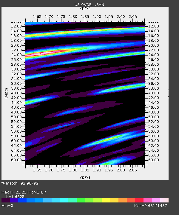
| Estimated Moho Depth: |
23.25 km |
| Estimated Crust Vp/Vs: |
1.66 |
| Assumed Crust Vp: |
6.279 km/s |
| Estimated Crust Vs: |
3.777 km/s |
| Estimated Crust Poisson's Ratio: |
0.22 |
|
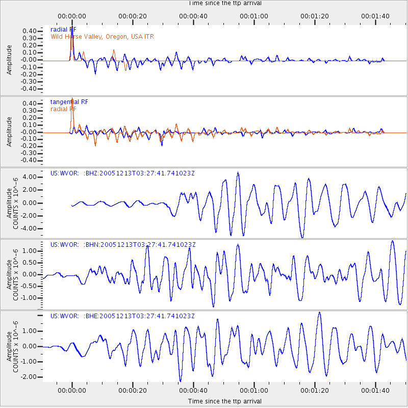
| Radial Match: |
92.96792 % |
| Radial Bump: |
294 |
| Transverse Match: |
91.73402 % |
| Transverse Bump: |
400 |
| SOD ConfigId: |
110165 |
| Insert Time: |
2010-03-05 04:23:09.744 +0000 |
| GWidth: |
2.5 |
| Max Bumps: |
400 |
| Tol: |
0.001 |
|
Signal To Noise
| Channel | StoN | STA | LTA |
| US:WVOR: :BHN:20051213T03:27:41.741023Z | 1.5570894 | 2.0943872E-7 | 1.3450655E-7 |
| US:WVOR: :BHE:20051213T03:27:41.741023Z | 2.0473847 | 3.7994417E-7 | 1.8557537E-7 |
| US:WVOR: :BHZ:20051213T03:27:41.741023Z | 3.873662 | 1.0352375E-6 | 2.6725036E-7 |
| Arrivals |
| Ps | 2.5 SECOND |
| PpPs | 9.6 SECOND |
| PsPs/PpSs | 12 SECOND |


