You are here: Home > Network List > TA - USArray Transportable Network (new EarthScope stations) Stations List
> Station L19K White Mountain, AK, USA > Earthquake Result Viewer
L19K White Mountain, AK, USA - Earthquake Result Viewer

| Earthquake location: |
Off Coast Of Jalisco, Mexico |
| Earthquake latitude/longitude: |
18.4/-105.2 |
| Earthquake time(UTC): |
2016/06/07 (159) 10:51:38 GMT |
| Earthquake Depth: |
10 km |
| Earthquake Magnitude: |
6.2 MWP |
| Earthquake Catalog/Contributor: |
NEIC PDE/NEIC COMCAT |
|
| Network: |
TA USArray Transportable Network (new EarthScope stations) |
| Station: |
L19K White Mountain, AK, USA |
| Lat/Lon: |
62.18 N/154.85 W |
| Elevation: |
650 m |
|
| Distance: |
55.6 deg |
| Az: |
334.303 deg |
| Baz: |
118.649 deg |
| Ray Param: |
0.06471357 |
| Estimated Moho Depth: |
38.0 km |
| Estimated Crust Vp/Vs: |
1.61 |
| Assumed Crust Vp: |
6.438 km/s |
| Estimated Crust Vs: |
4.011 km/s |
| Estimated Crust Poisson's Ratio: |
0.18 |
|
| Radial Match: |
89.003845 % |
| Radial Bump: |
400 |
| Transverse Match: |
85.17046 % |
| Transverse Bump: |
400 |
| SOD ConfigId: |
7422571 |
| Insert Time: |
2019-04-22 19:01:30.903 +0000 |
| GWidth: |
2.5 |
| Max Bumps: |
400 |
| Tol: |
0.001 |
|
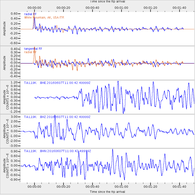
Signal To Noise
| Channel | StoN | STA | LTA |
| TA:L19K: :BHZ:20160607T11:00:42.49999Z | 15.777036 | 9.57708E-7 | 6.070266E-8 |
| TA:L19K: :BHN:20160607T11:00:42.49999Z | 4.7375746 | 2.1170186E-7 | 4.4685702E-8 |
| TA:L19K: :BHE:20160607T11:00:42.49999Z | 9.124317 | 4.0527635E-7 | 4.441717E-8 |
| Arrivals |
| Ps | 3.8 SECOND |
| PpPs | 15 SECOND |
| PsPs/PpSs | 18 SECOND |


