You are here: Home > Network List > TA - USArray Transportable Network (new EarthScope stations) Stations List
> Station M20K Styx River, AK, USA > Earthquake Result Viewer
M20K Styx River, AK, USA - Earthquake Result Viewer
| Earthquake location: |
Off Coast Of Jalisco, Mexico |
| Earthquake latitude/longitude: |
18.4/-105.2 |
| Earthquake time(UTC): |
2016/06/07 (159) 10:51:38 GMT |
| Earthquake Depth: |
10 km |
| Earthquake Magnitude: |
6.2 MWP |
| Earthquake Catalog/Contributor: |
NEIC PDE/NEIC COMCAT |
|
| Network: |
TA USArray Transportable Network (new EarthScope stations) |
| Station: |
M20K Styx River, AK, USA |
| Lat/Lon: |
61.88 N/153.13 W |
| Elevation: |
1107 m |
|
| Distance: |
54.7 deg |
| Az: |
334.471 deg |
| Baz: |
120.264 deg |
| Ray Param: |
0.0652809 |
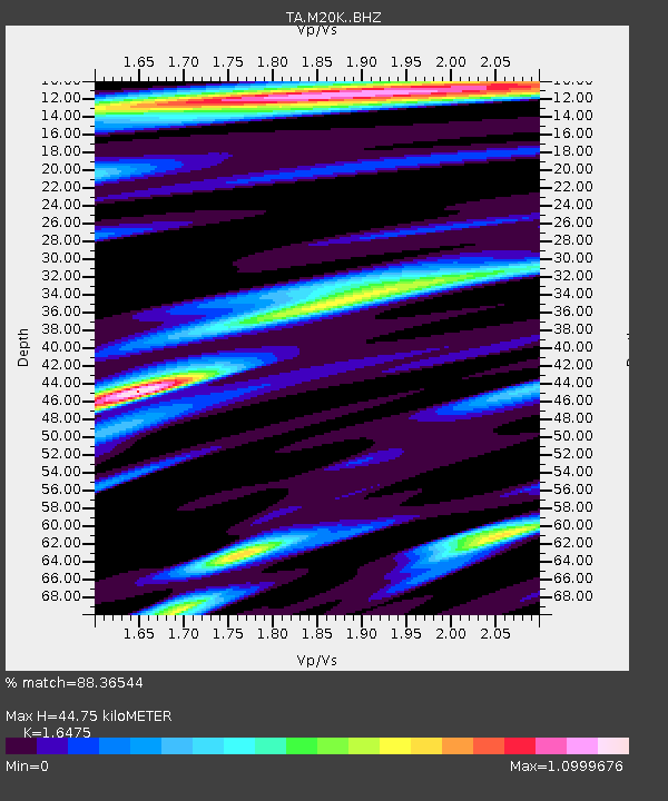
| Estimated Moho Depth: |
44.75 km |
| Estimated Crust Vp/Vs: |
1.65 |
| Assumed Crust Vp: |
6.566 km/s |
| Estimated Crust Vs: |
3.986 km/s |
| Estimated Crust Poisson's Ratio: |
0.21 |
|
| Radial Match: |
88.36544 % |
| Radial Bump: |
400 |
| Transverse Match: |
75.78368 % |
| Transverse Bump: |
400 |
| SOD ConfigId: |
7422571 |
| Insert Time: |
2019-04-22 19:01:35.996 +0000 |
| GWidth: |
2.5 |
| Max Bumps: |
400 |
| Tol: |
0.001 |
|

Signal To Noise
| Channel | StoN | STA | LTA |
| TA:M20K: :BHZ:20160607T11:00:36.325002Z | 20.8145 | 9.610595E-7 | 4.6172598E-8 |
| TA:M20K: :BHN:20160607T11:00:36.325002Z | 3.0823946 | 1.5385153E-7 | 4.9912988E-8 |
| TA:M20K: :BHE:20160607T11:00:36.325002Z | 6.817863 | 3.1924E-7 | 4.6824052E-8 |
| Arrivals |
| Ps | 4.7 SECOND |
| PpPs | 17 SECOND |
| PsPs/PpSs | 22 SECOND |


