You are here: Home > Network List > TA - USArray Transportable Network (new EarthScope stations) Stations List
> Station M53A WI Miller and Sons, Farmdale, OH, USA > Earthquake Result Viewer
M53A WI Miller and Sons, Farmdale, OH, USA - Earthquake Result Viewer

| Earthquake location: |
Off Coast Of Jalisco, Mexico |
| Earthquake latitude/longitude: |
18.4/-105.2 |
| Earthquake time(UTC): |
2016/06/07 (159) 10:51:38 GMT |
| Earthquake Depth: |
10 km |
| Earthquake Magnitude: |
6.2 MWP |
| Earthquake Catalog/Contributor: |
NEIC PDE/NEIC COMCAT |
|
| Network: |
TA USArray Transportable Network (new EarthScope stations) |
| Station: |
M53A WI Miller and Sons, Farmdale, OH, USA |
| Lat/Lon: |
41.44 N/80.68 W |
| Elevation: |
334 m |
|
| Distance: |
31.1 deg |
| Az: |
37.183 deg |
| Baz: |
229.746 deg |
| Ray Param: |
0.07916491 |
| Estimated Moho Depth: |
21.75 km |
| Estimated Crust Vp/Vs: |
2.10 |
| Assumed Crust Vp: |
6.483 km/s |
| Estimated Crust Vs: |
3.094 km/s |
| Estimated Crust Poisson's Ratio: |
0.35 |
|
| Radial Match: |
90.73545 % |
| Radial Bump: |
214 |
| Transverse Match: |
69.74746 % |
| Transverse Bump: |
400 |
| SOD ConfigId: |
7422571 |
| Insert Time: |
2019-04-22 19:01:41.230 +0000 |
| GWidth: |
2.5 |
| Max Bumps: |
400 |
| Tol: |
0.001 |
|
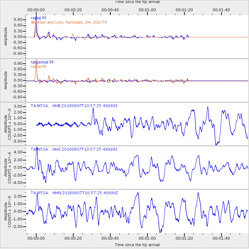
Signal To Noise
| Channel | StoN | STA | LTA |
| TA:M53A: :HHZ:20160607T10:57:25.49999Z | 13.594136 | 2.3897412E-6 | 1.7579205E-7 |
| TA:M53A: :HHN:20160607T10:57:25.49999Z | 6.8488026 | 1.0643919E-6 | 1.5541285E-7 |
| TA:M53A: :HHE:20160607T10:57:25.49999Z | 7.2260094 | 1.2064755E-6 | 1.6696292E-7 |
| Arrivals |
| Ps | 3.9 SECOND |
| PpPs | 9.7 SECOND |
| PsPs/PpSs | 14 SECOND |


