You are here: Home > Network List > TA - USArray Transportable Network (new EarthScope stations) Stations List
> Station N19K Bonanza Creek NPS repeater, AK, USA > Earthquake Result Viewer
N19K Bonanza Creek NPS repeater, AK, USA - Earthquake Result Viewer
| Earthquake location: |
Off Coast Of Jalisco, Mexico |
| Earthquake latitude/longitude: |
18.4/-105.2 |
| Earthquake time(UTC): |
2016/06/07 (159) 10:51:38 GMT |
| Earthquake Depth: |
10 km |
| Earthquake Magnitude: |
6.2 MWP |
| Earthquake Catalog/Contributor: |
NEIC PDE/NEIC COMCAT |
|
| Network: |
TA USArray Transportable Network (new EarthScope stations) |
| Station: |
N19K Bonanza Creek NPS repeater, AK, USA |
| Lat/Lon: |
60.81 N/154.48 W |
| Elevation: |
1144 m |
|
| Distance: |
54.8 deg |
| Az: |
332.934 deg |
| Baz: |
118.192 deg |
| Ray Param: |
0.06525097 |
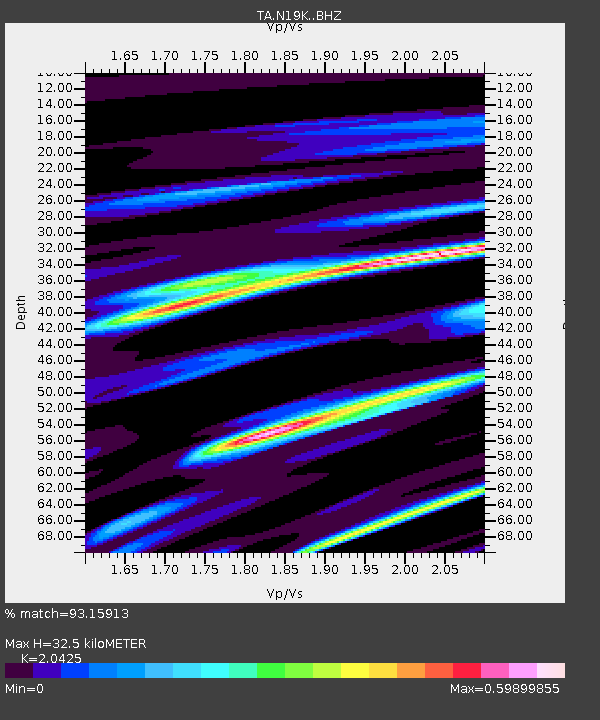
| Estimated Moho Depth: |
32.5 km |
| Estimated Crust Vp/Vs: |
2.04 |
| Assumed Crust Vp: |
6.566 km/s |
| Estimated Crust Vs: |
3.215 km/s |
| Estimated Crust Poisson's Ratio: |
0.34 |
|
| Radial Match: |
93.15913 % |
| Radial Bump: |
400 |
| Transverse Match: |
90.19597 % |
| Transverse Bump: |
400 |
| SOD ConfigId: |
7422571 |
| Insert Time: |
2019-04-22 19:01:45.057 +0000 |
| GWidth: |
2.5 |
| Max Bumps: |
400 |
| Tol: |
0.001 |
|

Signal To Noise
| Channel | StoN | STA | LTA |
| TA:N19K: :BHZ:20160607T11:00:36.650015Z | 12.306667 | 8.6060203E-7 | 6.992973E-8 |
| TA:N19K: :BHN:20160607T11:00:36.650015Z | 4.29667 | 2.478401E-7 | 5.7681902E-8 |
| TA:N19K: :BHE:20160607T11:00:36.650015Z | 6.444524 | 3.8743377E-7 | 6.011829E-8 |
| Arrivals |
| Ps | 5.4 SECOND |
| PpPs | 14 SECOND |
| PsPs/PpSs | 20 SECOND |


