You are here: Home > Network List > TA - USArray Transportable Network (new EarthScope stations) Stations List
> Station P17K Kvichak River, AK, USA > Earthquake Result Viewer
P17K Kvichak River, AK, USA - Earthquake Result Viewer

| Earthquake location: |
Off Coast Of Jalisco, Mexico |
| Earthquake latitude/longitude: |
18.4/-105.2 |
| Earthquake time(UTC): |
2016/06/07 (159) 10:51:38 GMT |
| Earthquake Depth: |
10 km |
| Earthquake Magnitude: |
6.2 MWP |
| Earthquake Catalog/Contributor: |
NEIC PDE/NEIC COMCAT |
|
| Network: |
TA USArray Transportable Network (new EarthScope stations) |
| Station: |
P17K Kvichak River, AK, USA |
| Lat/Lon: |
59.20 N/156.44 W |
| Elevation: |
91 m |
|
| Distance: |
54.9 deg |
| Az: |
330.62 deg |
| Baz: |
115.168 deg |
| Ray Param: |
0.06515123 |
| Estimated Moho Depth: |
30.75 km |
| Estimated Crust Vp/Vs: |
2.02 |
| Assumed Crust Vp: |
6.276 km/s |
| Estimated Crust Vs: |
3.107 km/s |
| Estimated Crust Poisson's Ratio: |
0.34 |
|
| Radial Match: |
84.62605 % |
| Radial Bump: |
400 |
| Transverse Match: |
70.16229 % |
| Transverse Bump: |
400 |
| SOD ConfigId: |
7422571 |
| Insert Time: |
2019-04-22 19:01:56.124 +0000 |
| GWidth: |
2.5 |
| Max Bumps: |
400 |
| Tol: |
0.001 |
|
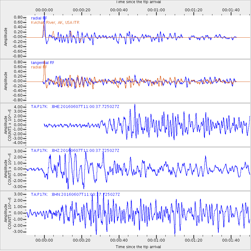
Signal To Noise
| Channel | StoN | STA | LTA |
| TA:P17K: :BHZ:20160607T11:00:37.725027Z | 9.71094 | 1.0856099E-6 | 1.1179246E-7 |
| TA:P17K: :BHN:20160607T11:00:37.725027Z | 1.4782745 | 4.042423E-7 | 2.734555E-7 |
| TA:P17K: :BHE:20160607T11:00:37.725027Z | 4.06315 | 8.379437E-7 | 2.0623008E-7 |
| Arrivals |
| Ps | 5.2 SECOND |
| PpPs | 14 SECOND |
| PsPs/PpSs | 19 SECOND |


