You are here: Home > Network List > XD14 - Illuminating the architecture of the greater Mount St. Helens magmatic systems f Stations List
> Station MD09 "Mount St Helens, WA" > Earthquake Result Viewer
MD09 "Mount St Helens, WA" - Earthquake Result Viewer
| Earthquake location: |
Off Coast Of Jalisco, Mexico |
| Earthquake latitude/longitude: |
18.4/-105.2 |
| Earthquake time(UTC): |
2016/06/07 (159) 10:51:38 GMT |
| Earthquake Depth: |
10 km |
| Earthquake Magnitude: |
6.2 MWP |
| Earthquake Catalog/Contributor: |
NEIC PDE/NEIC COMCAT |
|
| Network: |
XD Illuminating the architecture of the greater Mount St. Helens magmatic systems f |
| Station: |
MD09 "Mount St Helens, WA" |
| Lat/Lon: |
46.50 N/121.71 W |
| Elevation: |
959 m |
|
| Distance: |
31.2 deg |
| Az: |
337.689 deg |
| Baz: |
148.547 deg |
| Ray Param: |
0.079143636 |
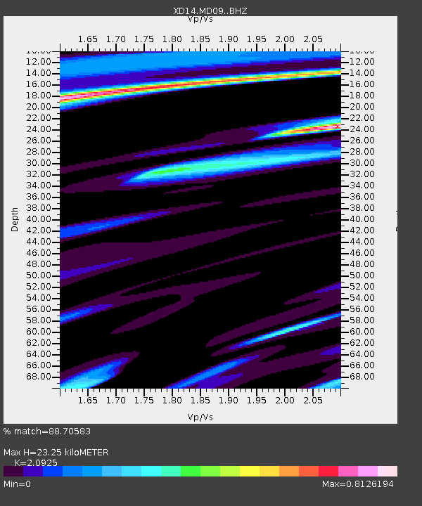
| Estimated Moho Depth: |
23.25 km |
| Estimated Crust Vp/Vs: |
2.09 |
| Assumed Crust Vp: |
6.597 km/s |
| Estimated Crust Vs: |
3.153 km/s |
| Estimated Crust Poisson's Ratio: |
0.35 |
|
| Radial Match: |
88.70583 % |
| Radial Bump: |
316 |
| Transverse Match: |
77.500984 % |
| Transverse Bump: |
400 |
| SOD ConfigId: |
7422571 |
| Insert Time: |
2019-04-22 19:03:07.592 +0000 |
| GWidth: |
2.5 |
| Max Bumps: |
400 |
| Tol: |
0.001 |
|

Signal To Noise
| Channel | StoN | STA | LTA |
| XD:MD09: :BHZ:20160607T10:57:26.39501Z | 12.201178 | 1.2140115E-6 | 9.949954E-8 |
| XD:MD09: :BHN:20160607T10:57:26.39501Z | 7.4727674 | 6.6052263E-7 | 8.839063E-8 |
| XD:MD09: :BHE:20160607T10:57:26.39501Z | 3.0725124 | 2.6665157E-7 | 8.6786166E-8 |
| Arrivals |
| Ps | 4.1 SECOND |
| PpPs | 10 SECOND |
| PsPs/PpSs | 14 SECOND |


