You are here: Home > Network List > XD14 - Illuminating the architecture of the greater Mount St. Helens magmatic systems f Stations List
> Station MD12 "Mount St Helens, WA" > Earthquake Result Viewer
MD12 "Mount St Helens, WA" - Earthquake Result Viewer
| Earthquake location: |
Off Coast Of Jalisco, Mexico |
| Earthquake latitude/longitude: |
18.4/-105.2 |
| Earthquake time(UTC): |
2016/06/07 (159) 10:51:38 GMT |
| Earthquake Depth: |
10 km |
| Earthquake Magnitude: |
6.2 MWP |
| Earthquake Catalog/Contributor: |
NEIC PDE/NEIC COMCAT |
|
| Network: |
XD Illuminating the architecture of the greater Mount St. Helens magmatic systems f |
| Station: |
MD12 "Mount St Helens, WA" |
| Lat/Lon: |
46.48 N/121.22 W |
| Elevation: |
1496 m |
|
| Distance: |
31.0 deg |
| Az: |
338.221 deg |
| Baz: |
149.354 deg |
| Ray Param: |
0.07919498 |
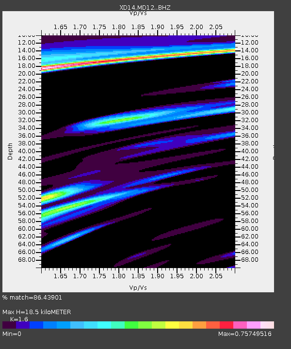
| Estimated Moho Depth: |
18.5 km |
| Estimated Crust Vp/Vs: |
1.60 |
| Assumed Crust Vp: |
6.597 km/s |
| Estimated Crust Vs: |
4.123 km/s |
| Estimated Crust Poisson's Ratio: |
0.18 |
|
| Radial Match: |
86.43901 % |
| Radial Bump: |
284 |
| Transverse Match: |
72.474945 % |
| Transverse Bump: |
400 |
| SOD ConfigId: |
7422571 |
| Insert Time: |
2019-04-22 19:03:07.939 +0000 |
| GWidth: |
2.5 |
| Max Bumps: |
400 |
| Tol: |
0.001 |
|

Signal To Noise
| Channel | StoN | STA | LTA |
| XD:MD12: :BHZ:20160607T10:57:24.675009Z | 12.187903 | 1.1249703E-6 | 9.2302194E-8 |
| XD:MD12: :BHN:20160607T10:57:24.675009Z | 7.6443996 | 6.5501774E-7 | 8.568597E-8 |
| XD:MD12: :BHE:20160607T10:57:24.675009Z | 4.698708 | 3.9349288E-7 | 8.374491E-8 |
| Arrivals |
| Ps | 1.8 SECOND |
| PpPs | 6.6 SECOND |
| PsPs/PpSs | 8.5 SECOND |


