You are here: Home > Network List > US - United States National Seismic Network Stations List
> Station WVOR Wild Horse Valley, Oregon, USA > Earthquake Result Viewer
WVOR Wild Horse Valley, Oregon, USA - Earthquake Result Viewer
| Earthquake location: |
Honduras |
| Earthquake latitude/longitude: |
15.8/-88.3 |
| Earthquake time(UTC): |
1999/07/11 (192) 14:14:16 GMT |
| Earthquake Depth: |
10 km |
| Earthquake Magnitude: |
6.0 MB, 6.6 MS, 6.7 MW, 6.3 ME |
| Earthquake Catalog/Contributor: |
WHDF/NEIC |
|
| Network: |
US United States National Seismic Network |
| Station: |
WVOR Wild Horse Valley, Oregon, USA |
| Lat/Lon: |
42.43 N/118.64 W |
| Elevation: |
1344 m |
|
| Distance: |
37.2 deg |
| Az: |
321.786 deg |
| Baz: |
126.438 deg |
| Ray Param: |
0.07629255 |
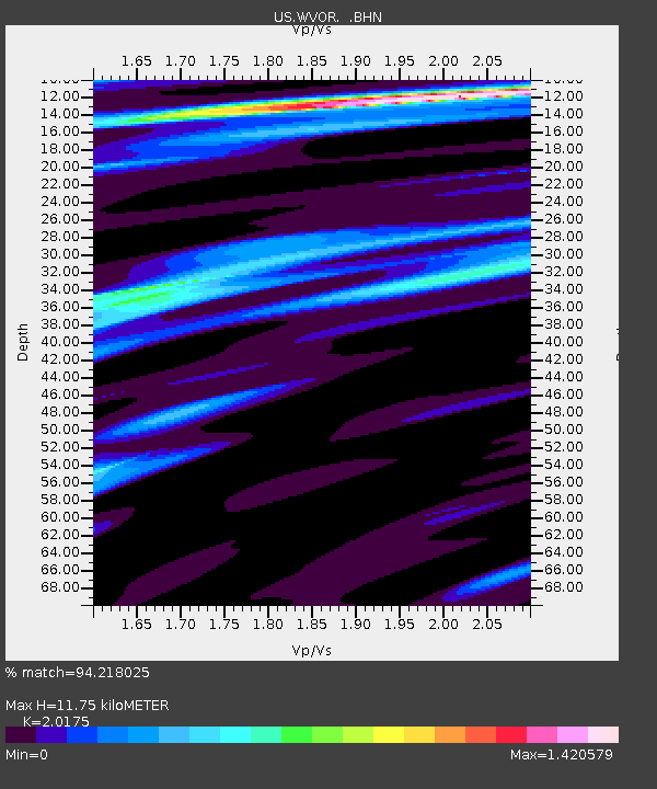
| Estimated Moho Depth: |
11.75 km |
| Estimated Crust Vp/Vs: |
2.02 |
| Assumed Crust Vp: |
6.279 km/s |
| Estimated Crust Vs: |
3.112 km/s |
| Estimated Crust Poisson's Ratio: |
0.34 |
|
| Radial Match: |
94.218025 % |
| Radial Bump: |
380 |
| Transverse Match: |
89.64852 % |
| Transverse Bump: |
400 |
| SOD ConfigId: |
110177 |
| Insert Time: |
2010-03-05 04:23:45.139 +0000 |
| GWidth: |
2.5 |
| Max Bumps: |
400 |
| Tol: |
0.001 |
|
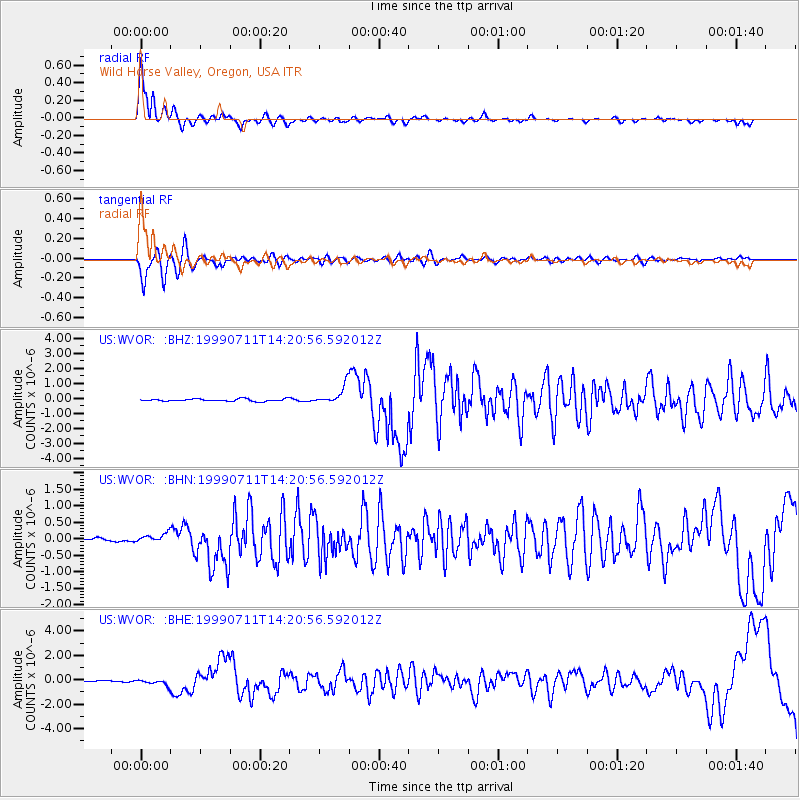
Signal To Noise
| Channel | StoN | STA | LTA |
| US:WVOR: :BHN:19990711T14:20:56.592012Z | 2.03411 | 1.33968E-7 | 6.586074E-8 |
| US:WVOR: :BHE:19990711T14:20:56.592012Z | 5.3631034 | 2.1833915E-7 | 4.0711345E-8 |
| US:WVOR: :BHZ:19990711T14:20:56.592012Z | 7.5622487 | 6.062133E-7 | 8.01631E-8 |
| Arrivals |
| Ps | 2.0 SECOND |
| PpPs | 5.3 SECOND |
| PsPs/PpSs | 7.3 SECOND |


