You are here: Home > Network List > XD14 - Illuminating the architecture of the greater Mount St. Helens magmatic systems f Stations List
> Station MI09 "Mount St Helens, WA" > Earthquake Result Viewer
MI09 "Mount St Helens, WA" - Earthquake Result Viewer
| Earthquake location: |
Off Coast Of Jalisco, Mexico |
| Earthquake latitude/longitude: |
18.4/-105.2 |
| Earthquake time(UTC): |
2016/06/07 (159) 10:51:38 GMT |
| Earthquake Depth: |
10 km |
| Earthquake Magnitude: |
6.2 MWP |
| Earthquake Catalog/Contributor: |
NEIC PDE/NEIC COMCAT |
|
| Network: |
XD Illuminating the architecture of the greater Mount St. Helens magmatic systems f |
| Station: |
MI09 "Mount St Helens, WA" |
| Lat/Lon: |
46.23 N/121.83 W |
| Elevation: |
1003 m |
|
| Distance: |
31.0 deg |
| Az: |
337.265 deg |
| Baz: |
148.091 deg |
| Ray Param: |
0.07919259 |
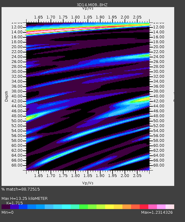
| Estimated Moho Depth: |
13.25 km |
| Estimated Crust Vp/Vs: |
1.72 |
| Assumed Crust Vp: |
6.597 km/s |
| Estimated Crust Vs: |
3.847 km/s |
| Estimated Crust Poisson's Ratio: |
0.24 |
|
| Radial Match: |
88.72515 % |
| Radial Bump: |
373 |
| Transverse Match: |
76.36175 % |
| Transverse Bump: |
400 |
| SOD ConfigId: |
7422571 |
| Insert Time: |
2019-04-22 19:03:28.144 +0000 |
| GWidth: |
2.5 |
| Max Bumps: |
400 |
| Tol: |
0.001 |
|

Signal To Noise
| Channel | StoN | STA | LTA |
| XD:MI09: :BHZ:20160607T10:57:24.74999Z | 10.098828 | 1.1849803E-6 | 1.173384E-7 |
| XD:MI09: :BHN:20160607T10:57:24.74999Z | 6.049927 | 6.636449E-7 | 1.0969469E-7 |
| XD:MI09: :BHE:20160607T10:57:24.74999Z | 2.6135702 | 3.9013378E-7 | 1.4927234E-7 |
| Arrivals |
| Ps | 1.6 SECOND |
| PpPs | 5.0 SECOND |
| PsPs/PpSs | 6.6 SECOND |


