You are here: Home > Network List > XD14 - Illuminating the architecture of the greater Mount St. Helens magmatic systems f Stations List
> Station MN09 "Mount St Helens, WA" > Earthquake Result Viewer
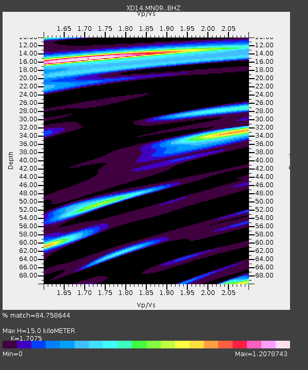
MN09 "Mount St Helens, WA" - Earthquake Result Viewer
| Earthquake location: |
Off Coast Of Jalisco, Mexico |
| Earthquake latitude/longitude: |
18.4/-105.2 |
| Earthquake time(UTC): |
2016/06/07 (159) 10:51:38 GMT |
| Earthquake Depth: |
10 km |
| Earthquake Magnitude: |
6.2 MWP |
| Earthquake Catalog/Contributor: |
NEIC PDE/NEIC COMCAT |
|
| Network: |
XD Illuminating the architecture of the greater Mount St. Helens magmatic systems f |
| Station: |
MN09 "Mount St Helens, WA" |
| Lat/Lon: |
46.00 N/121.84 W |
| Elevation: |
1254 m |
|
| Distance: |
30.8 deg |
| Az: |
337.02 deg |
| Baz: |
147.876 deg |
| Ray Param: |
0.07924281 |
| Estimated Moho Depth: |
15.0 km |
| Estimated Crust Vp/Vs: |
1.71 |
| Assumed Crust Vp: |
6.597 km/s |
| Estimated Crust Vs: |
3.864 km/s |
| Estimated Crust Poisson's Ratio: |
0.24 |
|
| Radial Match: |
84.758644 % |
| Radial Bump: |
276 |
| Transverse Match: |
79.32027 % |
| Transverse Bump: |
400 |
| SOD ConfigId: |
7422571 |
| Insert Time: |
2019-04-22 19:03:43.298 +0000 |
| GWidth: |
2.5 |
| Max Bumps: |
400 |
| Tol: |
0.001 |
|

Signal To Noise
| Channel | StoN | STA | LTA |
| XD:MN09: :BHZ:20160607T10:57:23.064993Z | 8.531439 | 1.6334245E-6 | 1.9145945E-7 |
| XD:MN09: :BHN:20160607T10:57:23.064993Z | 4.19496 | 1.0413761E-6 | 2.4824456E-7 |
| XD:MN09: :BHE:20160607T10:57:23.064993Z | 2.4485805 | 5.5623497E-7 | 2.271663E-7 |
| Arrivals |
| Ps | 1.8 SECOND |
| PpPs | 5.6 SECOND |
| PsPs/PpSs | 7.4 SECOND |


