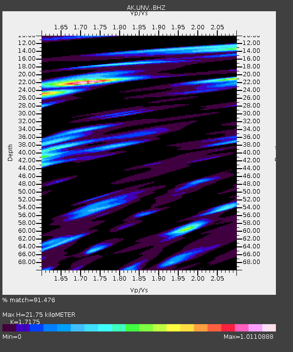
UNV Unalaska Valley - Earthquake Result Viewer

Earthquake location: Northern Molucca Sea
Earthquake latitude/longitude: 1.3/126.3
Earthquake time(UTC): 2016/06/07 (159) 19:15:15 GMT
Earthquake Depth: 31 km
Earthquake Magnitude: 6.3 MWW, 6.2 MWB, 6.3 MWC, 6.4 MWC, 6.5 MI, 6.6 MI
Earthquake Catalog/Contributor: NEIC PDE/NEIC COMCAT
Network: AK Alaska Regional Network
Station: UNV Unalaska Valley
Lat/Lon: 53.85 N/166.50 W
Elevation: 67 m
Distance: 75.6 deg
Az: 34.315 deg
Baz: 252.019 deg
Ray Param: 0.051499132
Estimated Moho Depth: 21.75 km
Estimated Crust Vp/Vs: 1.72
Assumed Crust Vp: 3.943 km/s
Estimated Crust Vs: 2.296 km/s
Estimated Crust Poisson's Ratio: 0.24
Radial Match: 91.476 %
Radial Bump: 400
Transverse Match: 89.24739 %
Transverse Bump: 400
SOD ConfigId: 7422571
Insert Time: 2019-04-22 19:12:05.405 +0000
GWidth: 2.5
Max Bumps: 400
Tol: 0.001

Signal To Noise

ChannelStoNSTALTA
AK:UNV: :BHZ:20160607T19:26:26.247991Z12.6910761.8195318E-61.4337097E-7
AK:UNV: :BHN:20160607T19:26:26.247991Z2.96928982.9349536E-79.884363E-8
AK:UNV: :BHE:20160607T19:26:26.247991Z5.61739256.826929E-71.21532E-7
Arrivals
Ps4.0 SECOND
PpPs15 SECOND
PsPs/PpSs19 SECOND