You are here: Home > Network List > AV - Alaska Volcano Observatory Stations List
> Station AKBB Akutan Broiad Bright, Akutan Volcano, Alaska > Earthquake Result Viewer
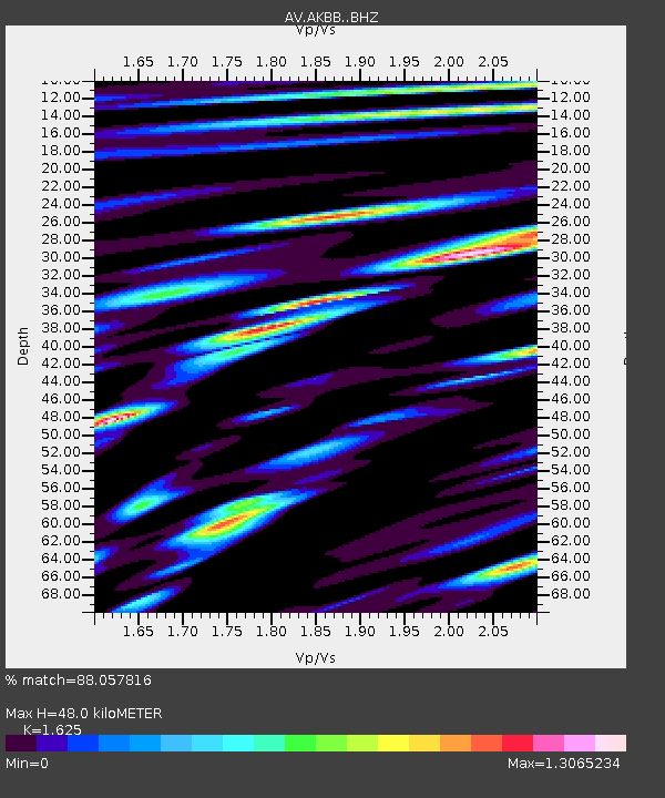
AKBB Akutan Broiad Bright, Akutan Volcano, Alaska - Earthquake Result Viewer
| Earthquake location: |
Northern Molucca Sea |
| Earthquake latitude/longitude: |
1.3/126.3 |
| Earthquake time(UTC): |
2016/06/07 (159) 19:15:15 GMT |
| Earthquake Depth: |
31 km |
| Earthquake Magnitude: |
6.3 MWW, 6.2 MWB, 6.3 MWC, 6.4 MWC, 6.5 MI, 6.6 MI |
| Earthquake Catalog/Contributor: |
NEIC PDE/NEIC COMCAT |
|
| Network: |
AV Alaska Volcano Observatory |
| Station: |
AKBB Akutan Broiad Bright, Akutan Volcano, Alaska |
| Lat/Lon: |
54.10 N/165.93 W |
| Elevation: |
310 m |
|
| Distance: |
76.0 deg |
| Az: |
34.173 deg |
| Baz: |
252.443 deg |
| Ray Param: |
0.051231425 |
| Estimated Moho Depth: |
48.0 km |
| Estimated Crust Vp/Vs: |
1.62 |
| Assumed Crust Vp: |
5.989 km/s |
| Estimated Crust Vs: |
3.686 km/s |
| Estimated Crust Poisson's Ratio: |
0.20 |
|
| Radial Match: |
88.057816 % |
| Radial Bump: |
400 |
| Transverse Match: |
89.69532 % |
| Transverse Bump: |
400 |
| SOD ConfigId: |
7422571 |
| Insert Time: |
2019-04-22 19:12:29.872 +0000 |
| GWidth: |
2.5 |
| Max Bumps: |
400 |
| Tol: |
0.001 |
|

Signal To Noise
| Channel | StoN | STA | LTA |
| AV:AKBB: :BHZ:20160607T19:26:28.518987Z | 7.098705 | 3.0638428E-6 | 4.316059E-7 |
| AV:AKBB: :BHN:20160607T19:26:28.518987Z | 6.1983457 | 1.7373756E-6 | 2.8029666E-7 |
| AV:AKBB: :BHE:20160607T19:26:28.518987Z | 6.677507 | 1.5744729E-6 | 2.3578754E-7 |
| Arrivals |
| Ps | 5.2 SECOND |
| PpPs | 20 SECOND |
| PsPs/PpSs | 26 SECOND |


