You are here: Home > Network List > AV - Alaska Volcano Observatory Stations List
> Station AUCH Augustine Cone H, Augustine Volcano, Alaska > Earthquake Result Viewer
AUCH Augustine Cone H, Augustine Volcano, Alaska - Earthquake Result Viewer

| Earthquake location: |
Northern Molucca Sea |
| Earthquake latitude/longitude: |
1.3/126.3 |
| Earthquake time(UTC): |
2016/06/07 (159) 19:15:15 GMT |
| Earthquake Depth: |
31 km |
| Earthquake Magnitude: |
6.3 MWW, 6.2 MWB, 6.3 MWC, 6.4 MWC, 6.5 MI, 6.6 MI |
| Earthquake Catalog/Contributor: |
NEIC PDE/NEIC COMCAT |
|
| Network: |
AV Alaska Volcano Observatory |
| Station: |
AUCH Augustine Cone H, Augustine Volcano, Alaska |
| Lat/Lon: |
59.36 N/153.44 W |
| Elevation: |
916 m |
|
| Distance: |
83.9 deg |
| Az: |
30.503 deg |
| Baz: |
262.245 deg |
| Ray Param: |
0.045829955 |
| Estimated Moho Depth: |
22.5 km |
| Estimated Crust Vp/Vs: |
1.94 |
| Assumed Crust Vp: |
5.989 km/s |
| Estimated Crust Vs: |
3.083 km/s |
| Estimated Crust Poisson's Ratio: |
0.32 |
|
| Radial Match: |
86.68602 % |
| Radial Bump: |
400 |
| Transverse Match: |
86.380905 % |
| Transverse Bump: |
400 |
| SOD ConfigId: |
7422571 |
| Insert Time: |
2019-04-22 19:12:34.262 +0000 |
| GWidth: |
2.5 |
| Max Bumps: |
400 |
| Tol: |
0.001 |
|
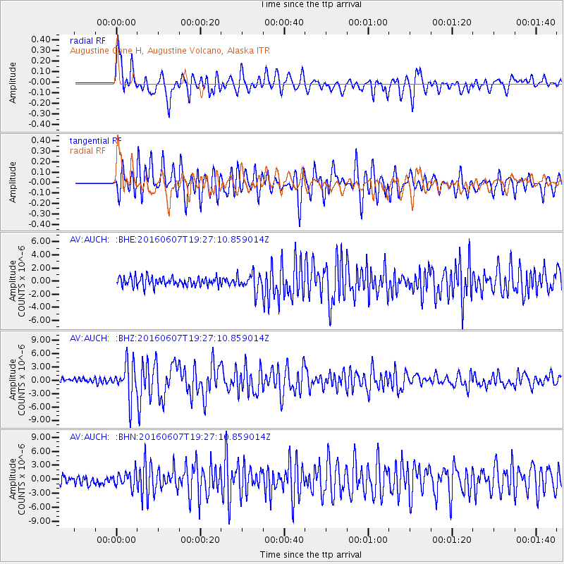
Signal To Noise
| Channel | StoN | STA | LTA |
| AV:AUCH: :BHZ:20160607T19:27:10.859014Z | 9.321267 | 3.9095166E-6 | 4.1941902E-7 |
| AV:AUCH: :BHN:20160607T19:27:10.859014Z | 1.8132272 | 1.6471013E-6 | 9.083811E-7 |
| AV:AUCH: :BHE:20160607T19:27:10.859014Z | 1.979682 | 1.3374508E-6 | 6.755887E-7 |
| Arrivals |
| Ps | 3.6 SECOND |
| PpPs | 11 SECOND |
| PsPs/PpSs | 14 SECOND |


