You are here: Home > Network List > AV - Alaska Volcano Observatory Stations List
> Station WECS Cape Sarichef, Westdahl Peak, Alaska > Earthquake Result Viewer
WECS Cape Sarichef, Westdahl Peak, Alaska - Earthquake Result Viewer
| Earthquake location: |
Northern Molucca Sea |
| Earthquake latitude/longitude: |
1.3/126.3 |
| Earthquake time(UTC): |
2016/06/07 (159) 19:15:15 GMT |
| Earthquake Depth: |
31 km |
| Earthquake Magnitude: |
6.3 MWW, 6.2 MWB, 6.3 MWC, 6.4 MWC, 6.5 MI, 6.6 MI |
| Earthquake Catalog/Contributor: |
NEIC PDE/NEIC COMCAT |
|
| Network: |
AV Alaska Volcano Observatory |
| Station: |
WECS Cape Sarichef, Westdahl Peak, Alaska |
| Lat/Lon: |
54.53 N/164.78 W |
| Elevation: |
639 m |
|
| Distance: |
76.8 deg |
| Az: |
33.952 deg |
| Baz: |
253.326 deg |
| Ray Param: |
0.050711595 |
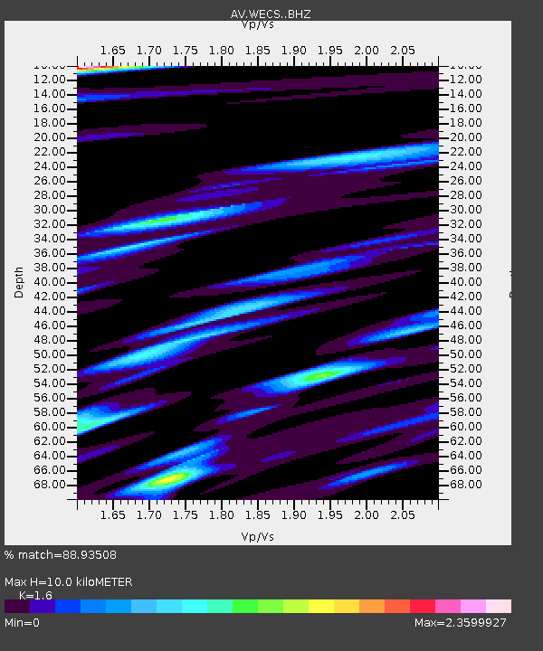
| Estimated Moho Depth: |
10.0 km |
| Estimated Crust Vp/Vs: |
1.60 |
| Assumed Crust Vp: |
5.989 km/s |
| Estimated Crust Vs: |
3.743 km/s |
| Estimated Crust Poisson's Ratio: |
0.18 |
|
| Radial Match: |
88.93508 % |
| Radial Bump: |
400 |
| Transverse Match: |
86.16385 % |
| Transverse Bump: |
400 |
| SOD ConfigId: |
7422571 |
| Insert Time: |
2019-04-22 19:12:47.928 +0000 |
| GWidth: |
2.5 |
| Max Bumps: |
400 |
| Tol: |
0.001 |
|

Signal To Noise
| Channel | StoN | STA | LTA |
| AV:WECS: :BHZ:20160607T19:26:32.898992Z | 4.813899 | 1.089372E-6 | 2.2629723E-7 |
| AV:WECS: :BHN:20160607T19:26:32.898992Z | 1.0366329 | 3.9745862E-7 | 3.8341307E-7 |
| AV:WECS: :BHE:20160607T19:26:32.898992Z | 1.8856275 | 6.701744E-7 | 3.5541188E-7 |
| Arrivals |
| Ps | 1.0 SECOND |
| PpPs | 4.2 SECOND |
| PsPs/PpSs | 5.2 SECOND |


