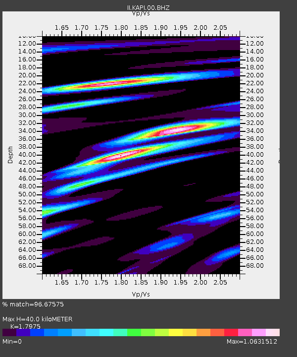
KAPI Kappang, Sulawesi, Indonesia - Earthquake Result Viewer

Earthquake location: Fox Islands, Aleutian Islands
Earthquake latitude/longitude: 52.6/-167.1
Earthquake time(UTC): 2009/10/13 (286) 20:21:53 GMT
Earthquake Depth: 14 km
Earthquake Magnitude: 5.9 MB, 6.4 MS, 6.4 MW, 6.4 MW
Earthquake Catalog/Contributor: WHDF/NEIC
Network: II Global Seismograph Network (GSN - IRIS/IDA)
Station: KAPI Kappang, Sulawesi, Indonesia
Lat/Lon: 5.01 S/119.75 E
Elevation: 300 m
Distance: 83.8 deg
Az: 253.519 deg
Baz: 35.948 deg
Ray Param: 0.04590334
Estimated Moho Depth: 40.0 km
Estimated Crust Vp/Vs: 1.80
Assumed Crust Vp: 6.343 km/s
Estimated Crust Vs: 3.529 km/s
Estimated Crust Poisson's Ratio: 0.28
Radial Match: 96.67575 %
Radial Bump: 359
Transverse Match: 91.72781 %
Transverse Bump: 400
SOD ConfigId: 1
Insert Time: 2010-02-19 00:46:07.159 +0000
GWidth: 2.5
Max Bumps: 400
Tol: 0.001

Signal To Noise

ChannelStoNSTALTA
II:KAPI:00:BHZ:20091013T20:33:50.629016Z8.1940037.217782E-78.808615E-8
II:KAPI:00:BHN:20091013T20:33:50.629993Z4.16406732.2405514E-75.38068E-8
II:KAPI:00:BHE:20091013T20:33:50.629993Z2.19086581.494924E-76.823439E-8
Arrivals
Ps5.2 SECOND
PpPs17 SECOND
PsPs/PpSs22 SECOND