You are here: Home > Network List > TA - USArray Transportable Network (new EarthScope stations) Stations List
> Station J26L Joseph Creek, AK, USA > Earthquake Result Viewer
J26L Joseph Creek, AK, USA - Earthquake Result Viewer
| Earthquake location: |
Northern Molucca Sea |
| Earthquake latitude/longitude: |
1.3/126.3 |
| Earthquake time(UTC): |
2016/06/07 (159) 19:15:15 GMT |
| Earthquake Depth: |
31 km |
| Earthquake Magnitude: |
6.3 MWW, 6.2 MWB, 6.3 MWC, 6.4 MWC, 6.5 MI, 6.6 MI |
| Earthquake Catalog/Contributor: |
NEIC PDE/NEIC COMCAT |
|
| Network: |
TA USArray Transportable Network (new EarthScope stations) |
| Station: |
J26L Joseph Creek, AK, USA |
| Lat/Lon: |
64.50 N/143.56 W |
| Elevation: |
1144 m |
|
| Distance: |
88.9 deg |
| Az: |
25.654 deg |
| Baz: |
270.658 deg |
| Ray Param: |
0.042228576 |
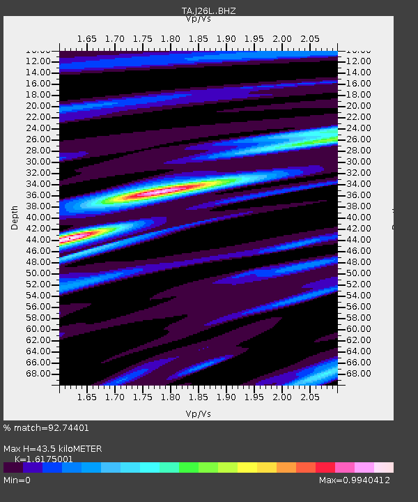
| Estimated Moho Depth: |
43.5 km |
| Estimated Crust Vp/Vs: |
1.62 |
| Assumed Crust Vp: |
6.566 km/s |
| Estimated Crust Vs: |
4.059 km/s |
| Estimated Crust Poisson's Ratio: |
0.19 |
|
| Radial Match: |
92.74401 % |
| Radial Bump: |
400 |
| Transverse Match: |
78.54967 % |
| Transverse Bump: |
400 |
| SOD ConfigId: |
7422571 |
| Insert Time: |
2019-04-22 19:15:22.309 +0000 |
| GWidth: |
2.5 |
| Max Bumps: |
400 |
| Tol: |
0.001 |
|
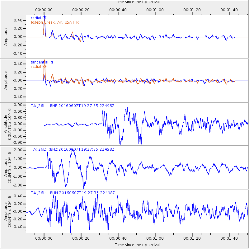
Signal To Noise
| Channel | StoN | STA | LTA |
| TA:J26L: :BHZ:20160607T19:27:35.22498Z | 12.172234 | 6.5604206E-7 | 5.38966E-8 |
| TA:J26L: :BHN:20160607T19:27:35.22498Z | 3.5991561 | 1.532514E-7 | 4.2579813E-8 |
| TA:J26L: :BHE:20160607T19:27:35.22498Z | 8.33874 | 2.828792E-7 | 3.392349E-8 |
| Arrivals |
| Ps | 4.2 SECOND |
| PpPs | 17 SECOND |
| PsPs/PpSs | 21 SECOND |


