You are here: Home > Network List > TA - USArray Transportable Network (new EarthScope stations) Stations List
> Station M20K Styx River, AK, USA > Earthquake Result Viewer
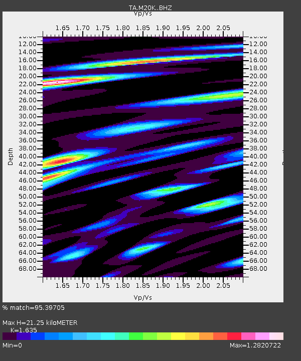
M20K Styx River, AK, USA - Earthquake Result Viewer
| Earthquake location: |
Northern Molucca Sea |
| Earthquake latitude/longitude: |
1.3/126.3 |
| Earthquake time(UTC): |
2016/06/07 (159) 19:15:15 GMT |
| Earthquake Depth: |
31 km |
| Earthquake Magnitude: |
6.3 MWW, 6.2 MWB, 6.3 MWC, 6.4 MWC, 6.5 MI, 6.6 MI |
| Earthquake Catalog/Contributor: |
NEIC PDE/NEIC COMCAT |
|
| Network: |
TA USArray Transportable Network (new EarthScope stations) |
| Station: |
M20K Styx River, AK, USA |
| Lat/Lon: |
61.88 N/153.13 W |
| Elevation: |
1107 m |
|
| Distance: |
84.4 deg |
| Az: |
28.006 deg |
| Baz: |
262.262 deg |
| Ray Param: |
0.045485985 |
| Estimated Moho Depth: |
21.25 km |
| Estimated Crust Vp/Vs: |
1.63 |
| Assumed Crust Vp: |
6.566 km/s |
| Estimated Crust Vs: |
4.016 km/s |
| Estimated Crust Poisson's Ratio: |
0.20 |
|
| Radial Match: |
95.39705 % |
| Radial Bump: |
400 |
| Transverse Match: |
89.12224 % |
| Transverse Bump: |
400 |
| SOD ConfigId: |
7422571 |
| Insert Time: |
2019-04-22 19:15:28.838 +0000 |
| GWidth: |
2.5 |
| Max Bumps: |
400 |
| Tol: |
0.001 |
|

Signal To Noise
| Channel | StoN | STA | LTA |
| TA:M20K: :BHZ:20160607T19:27:13.375005Z | 36.495018 | 2.350293E-6 | 6.4400375E-8 |
| TA:M20K: :BHN:20160607T19:27:13.375005Z | 3.3082066 | 2.2131167E-7 | 6.6897776E-8 |
| TA:M20K: :BHE:20160607T19:27:13.375005Z | 21.52769 | 8.5419555E-7 | 3.9678923E-8 |
| Arrivals |
| Ps | 2.1 SECOND |
| PpPs | 8.3 SECOND |
| PsPs/PpSs | 10 SECOND |


