You are here: Home > Network List > TA - USArray Transportable Network (new EarthScope stations) Stations List
> Station M23K Glacier View, AK, USA > Earthquake Result Viewer
M23K Glacier View, AK, USA - Earthquake Result Viewer
| Earthquake location: |
Northern Molucca Sea |
| Earthquake latitude/longitude: |
1.3/126.3 |
| Earthquake time(UTC): |
2016/06/07 (159) 19:15:15 GMT |
| Earthquake Depth: |
31 km |
| Earthquake Magnitude: |
6.3 MWW, 6.2 MWB, 6.3 MWC, 6.4 MWC, 6.5 MI, 6.6 MI |
| Earthquake Catalog/Contributor: |
NEIC PDE/NEIC COMCAT |
|
| Network: |
TA USArray Transportable Network (new EarthScope stations) |
| Station: |
M23K Glacier View, AK, USA |
| Lat/Lon: |
61.79 N/147.73 W |
| Elevation: |
583 m |
|
| Distance: |
86.9 deg |
| Az: |
28.335 deg |
| Baz: |
267.047 deg |
| Ray Param: |
0.043658793 |
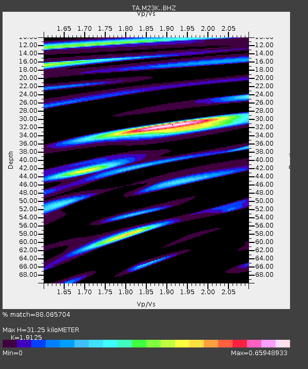
| Estimated Moho Depth: |
31.25 km |
| Estimated Crust Vp/Vs: |
1.91 |
| Assumed Crust Vp: |
6.566 km/s |
| Estimated Crust Vs: |
3.433 km/s |
| Estimated Crust Poisson's Ratio: |
0.31 |
|
| Radial Match: |
88.065704 % |
| Radial Bump: |
400 |
| Transverse Match: |
84.14682 % |
| Transverse Bump: |
400 |
| SOD ConfigId: |
7422571 |
| Insert Time: |
2019-04-22 19:15:29.499 +0000 |
| GWidth: |
2.5 |
| Max Bumps: |
400 |
| Tol: |
0.001 |
|

Signal To Noise
| Channel | StoN | STA | LTA |
| TA:M23K: :BHZ:20160607T19:27:25.950017Z | 11.97132 | 8.599963E-7 | 7.183805E-8 |
| TA:M23K: :BHN:20160607T19:27:25.950017Z | 2.0265968 | 1.7253053E-7 | 8.513314E-8 |
| TA:M23K: :BHE:20160607T19:27:25.950017Z | 3.4594674 | 2.7270002E-7 | 7.882717E-8 |
| Arrivals |
| Ps | 4.4 SECOND |
| PpPs | 14 SECOND |
| PsPs/PpSs | 18 SECOND |


