You are here: Home > Network List > TA - USArray Transportable Network (new EarthScope stations) Stations List
> Station M30M Minto, Yukon, CA > Earthquake Result Viewer
M30M Minto, Yukon, CA - Earthquake Result Viewer
| Earthquake location: |
Northern Molucca Sea |
| Earthquake latitude/longitude: |
1.3/126.3 |
| Earthquake time(UTC): |
2016/06/07 (159) 19:15:15 GMT |
| Earthquake Depth: |
31 km |
| Earthquake Magnitude: |
6.3 MWW, 6.2 MWB, 6.3 MWC, 6.4 MWC, 6.5 MI, 6.6 MI |
| Earthquake Catalog/Contributor: |
NEIC PDE/NEIC COMCAT |
|
| Network: |
TA USArray Transportable Network (new EarthScope stations) |
| Station: |
M30M Minto, Yukon, CA |
| Lat/Lon: |
62.58 N/136.79 W |
| Elevation: |
782 m |
|
| Distance: |
92.0 deg |
| Az: |
27.385 deg |
| Baz: |
276.7 deg |
| Ray Param: |
0.04151434 |
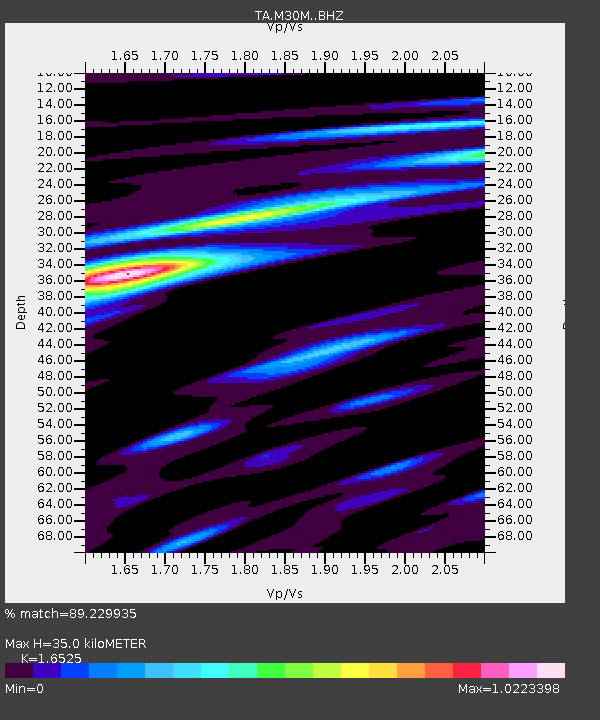
| Estimated Moho Depth: |
35.0 km |
| Estimated Crust Vp/Vs: |
1.65 |
| Assumed Crust Vp: |
6.566 km/s |
| Estimated Crust Vs: |
3.973 km/s |
| Estimated Crust Poisson's Ratio: |
0.21 |
|
| Radial Match: |
89.229935 % |
| Radial Bump: |
400 |
| Transverse Match: |
84.13012 % |
| Transverse Bump: |
400 |
| SOD ConfigId: |
7422571 |
| Insert Time: |
2019-04-22 19:15:34.405 +0000 |
| GWidth: |
2.5 |
| Max Bumps: |
400 |
| Tol: |
0.001 |
|

Signal To Noise
| Channel | StoN | STA | LTA |
| TA:M30M: :BHZ:20160607T19:27:49.825017Z | 12.78369 | 9.1293805E-7 | 7.141428E-8 |
| TA:M30M: :BHN:20160607T19:27:49.825017Z | 2.9889193 | 1.2298834E-7 | 4.11481E-8 |
| TA:M30M: :BHE:20160607T19:27:49.825017Z | 8.572496 | 4.2143904E-7 | 4.9161763E-8 |
| Arrivals |
| Ps | 3.6 SECOND |
| PpPs | 14 SECOND |
| PsPs/PpSs | 17 SECOND |


