You are here: Home > Network List > KZ - Kazakhstan Network Stations List
> Station ABKAR Akbulak array,AB31, Kazakhstan > Earthquake Result Viewer
ABKAR Akbulak array,AB31, Kazakhstan - Earthquake Result Viewer
| Earthquake location: |
South Of Sumbawa, Indonesia |
| Earthquake latitude/longitude: |
-11.5/116.2 |
| Earthquake time(UTC): |
2016/06/09 (161) 04:13:08 GMT |
| Earthquake Depth: |
30 km |
| Earthquake Magnitude: |
6.2 MWP |
| Earthquake Catalog/Contributor: |
NEIC PDE/NEIC COMCAT |
|
| Network: |
KZ Kazakhstan Network |
| Station: |
ABKAR Akbulak array,AB31, Kazakhstan |
| Lat/Lon: |
49.26 N/59.94 E |
| Elevation: |
362 m |
|
| Distance: |
78.0 deg |
| Az: |
326.143 deg |
| Baz: |
123.533 deg |
| Ray Param: |
0.04987376 |
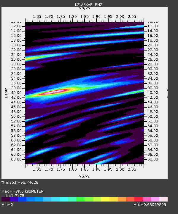
| Estimated Moho Depth: |
39.5 km |
| Estimated Crust Vp/Vs: |
1.72 |
| Assumed Crust Vp: |
6.35 km/s |
| Estimated Crust Vs: |
3.697 km/s |
| Estimated Crust Poisson's Ratio: |
0.24 |
|
| Radial Match: |
98.74026 % |
| Radial Bump: |
363 |
| Transverse Match: |
93.16862 % |
| Transverse Bump: |
400 |
| SOD ConfigId: |
7422571 |
| Insert Time: |
2019-04-22 19:28:07.527 +0000 |
| GWidth: |
2.5 |
| Max Bumps: |
400 |
| Tol: |
0.001 |
|

Signal To Noise
| Channel | StoN | STA | LTA |
| KZ:ABKAR: :BHZ:20160609T04:24:33.175991Z | 41.25459 | 3.1043012E-6 | 7.5247414E-8 |
| KZ:ABKAR: :BHN:20160609T04:24:33.175991Z | 10.919258 | 7.0121575E-7 | 6.4218256E-8 |
| KZ:ABKAR: :BHE:20160609T04:24:33.175991Z | 19.618883 | 1.1457917E-6 | 5.840249E-8 |
| Arrivals |
| Ps | 4.6 SECOND |
| PpPs | 16 SECOND |
| PsPs/PpSs | 21 SECOND |


