You are here: Home > Network List > KZ - Kazakhstan Network Stations List
> Station OTUK ORTAU, Kazakstan > Earthquake Result Viewer
OTUK ORTAU, Kazakstan - Earthquake Result Viewer
| Earthquake location: |
South Of Sumbawa, Indonesia |
| Earthquake latitude/longitude: |
-11.5/116.2 |
| Earthquake time(UTC): |
2016/06/09 (161) 04:13:08 GMT |
| Earthquake Depth: |
30 km |
| Earthquake Magnitude: |
6.2 MWP |
| Earthquake Catalog/Contributor: |
NEIC PDE/NEIC COMCAT |
|
| Network: |
KZ Kazakhstan Network |
| Station: |
OTUK ORTAU, Kazakstan |
| Lat/Lon: |
48.24 N/72.34 E |
| Elevation: |
750 m |
|
| Distance: |
71.0 deg |
| Az: |
330.652 deg |
| Baz: |
134.046 deg |
| Ray Param: |
0.05455643 |
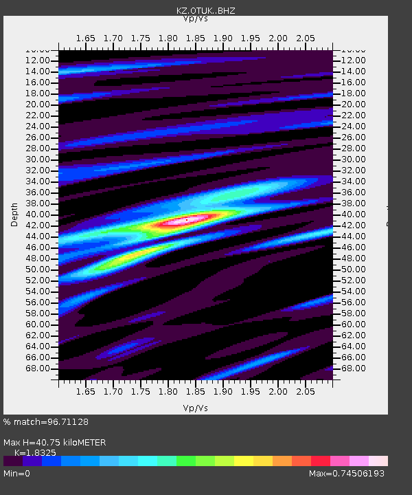
| Estimated Moho Depth: |
40.75 km |
| Estimated Crust Vp/Vs: |
1.83 |
| Assumed Crust Vp: |
6.571 km/s |
| Estimated Crust Vs: |
3.586 km/s |
| Estimated Crust Poisson's Ratio: |
0.29 |
|
| Radial Match: |
96.71128 % |
| Radial Bump: |
361 |
| Transverse Match: |
78.67616 % |
| Transverse Bump: |
400 |
| SOD ConfigId: |
7422571 |
| Insert Time: |
2019-04-22 19:28:12.094 +0000 |
| GWidth: |
2.5 |
| Max Bumps: |
400 |
| Tol: |
0.001 |
|

Signal To Noise
| Channel | StoN | STA | LTA |
| KZ:OTUK: :BHZ:20160609T04:23:49.451016Z | 24.697582 | 1.1844664E-6 | 4.7958803E-8 |
| KZ:OTUK: :BHN:20160609T04:23:49.451016Z | 10.707245 | 3.0306654E-7 | 2.8304811E-8 |
| KZ:OTUK: :BHE:20160609T04:23:49.451016Z | 5.502476 | 3.662181E-7 | 6.655515E-8 |
| Arrivals |
| Ps | 5.4 SECOND |
| PpPs | 17 SECOND |
| PsPs/PpSs | 22 SECOND |


