You are here: Home > Network List > TJ - Tajikistan National Seismic Network Stations List
> Station GARM Garm, Tajikistan > Earthquake Result Viewer
GARM Garm, Tajikistan - Earthquake Result Viewer
| Earthquake location: |
South Of Sumbawa, Indonesia |
| Earthquake latitude/longitude: |
-11.5/116.2 |
| Earthquake time(UTC): |
2016/06/09 (161) 04:13:08 GMT |
| Earthquake Depth: |
30 km |
| Earthquake Magnitude: |
6.2 MWP |
| Earthquake Catalog/Contributor: |
NEIC PDE/NEIC COMCAT |
|
| Network: |
TJ Tajikistan National Seismic Network |
| Station: |
GARM Garm, Tajikistan |
| Lat/Lon: |
39.00 N/70.32 E |
| Elevation: |
1305 m |
|
| Distance: |
65.9 deg |
| Az: |
322.196 deg |
| Baz: |
129.542 deg |
| Ray Param: |
0.057894036 |
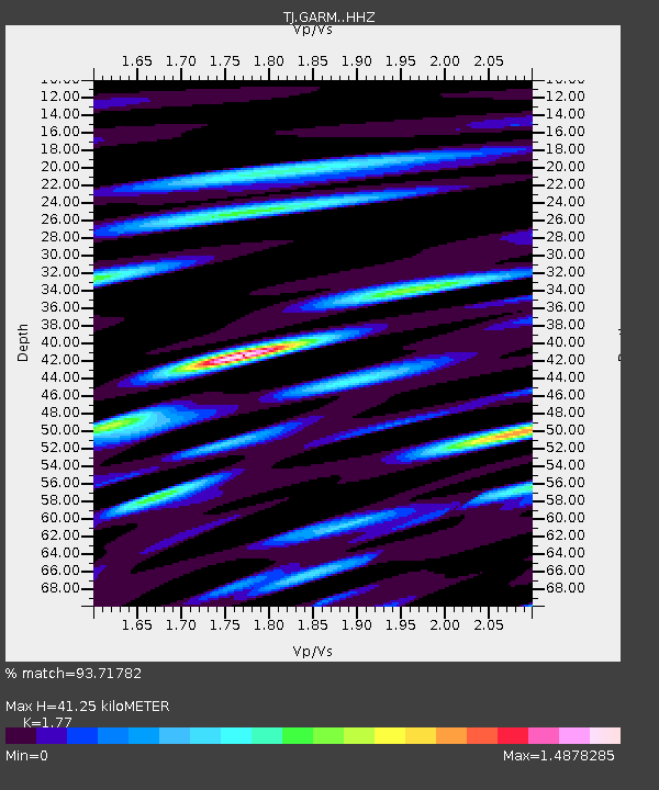
| Estimated Moho Depth: |
41.25 km |
| Estimated Crust Vp/Vs: |
1.77 |
| Assumed Crust Vp: |
6.306 km/s |
| Estimated Crust Vs: |
3.563 km/s |
| Estimated Crust Poisson's Ratio: |
0.27 |
|
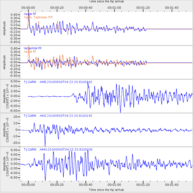
| Radial Match: |
93.71782 % |
| Radial Bump: |
400 |
| Transverse Match: |
85.27793 % |
| Transverse Bump: |
400 |
| SOD ConfigId: |
7422571 |
| Insert Time: |
2019-04-22 19:28:44.207 +0000 |
| GWidth: |
2.5 |
| Max Bumps: |
400 |
| Tol: |
0.001 |
|
Signal To Noise
| Channel | StoN | STA | LTA |
| TJ:GARM: :HHZ:20160609T04:23:20.810024Z | 23.68436 | 3.7608845E-6 | 1.5879189E-7 |
| TJ:GARM: :HHN:20160609T04:23:20.810024Z | 7.3057504 | 9.547723E-7 | 1.3068778E-7 |
| TJ:GARM: :HHE:20160609T04:23:20.810024Z | 12.400626 | 1.0120572E-6 | 8.161339E-8 |
| Arrivals |
| Ps | 5.2 SECOND |
| PpPs | 17 SECOND |
| PsPs/PpSs | 23 SECOND |


