You are here: Home > Network List > AV - Alaska Volcano Observatory Stations List
> Station SPCR Ckakachatna River, Mount Spurr, Alaska > Earthquake Result Viewer
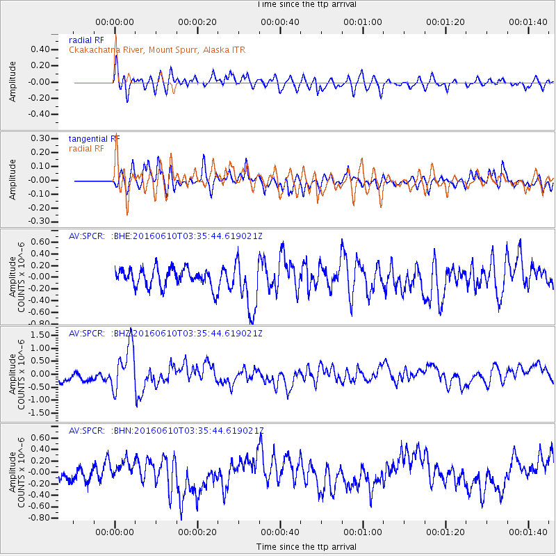
SPCR Ckakachatna River, Mount Spurr, Alaska - Earthquake Result Viewer
*The percent match for this event was below the threshold and hence no stack was calculated.
| Earthquake location: |
Near Coast Of Nicaragua |
| Earthquake latitude/longitude: |
12.8/-87.0 |
| Earthquake time(UTC): |
2016/06/10 (162) 03:25:22 GMT |
| Earthquake Depth: |
10 km |
| Earthquake Magnitude: |
6.1 MWP |
| Earthquake Catalog/Contributor: |
NEIC PDE/NEIC COMCAT |
|
| Network: |
AV Alaska Volcano Observatory |
| Station: |
SPCR Ckakachatna River, Mount Spurr, Alaska |
| Lat/Lon: |
61.20 N/152.21 W |
| Elevation: |
984 m |
|
| Distance: |
67.0 deg |
| Az: |
331.467 deg |
| Baz: |
105.832 deg |
| Ray Param: |
$rayparam |
*The percent match for this event was below the threshold and hence was not used in the summary stack. |
|
| Radial Match: |
61.551357 % |
| Radial Bump: |
400 |
| Transverse Match: |
51.772247 % |
| Transverse Bump: |
400 |
| SOD ConfigId: |
7422571 |
| Insert Time: |
2019-04-22 19:31:53.866 +0000 |
| GWidth: |
2.5 |
| Max Bumps: |
400 |
| Tol: |
0.001 |
|
Signal To Noise
| Channel | StoN | STA | LTA |
| AV:SPCR: :BHZ:20160610T03:35:44.619021Z | 4.0623903 | 8.913512E-7 | 2.1941544E-7 |
| AV:SPCR: :BHN:20160610T03:35:44.619021Z | 1.027632 | 1.7022161E-7 | 1.6564451E-7 |
| AV:SPCR: :BHE:20160610T03:35:44.619021Z | 2.9184084 | 4.5143773E-7 | 1.5468628E-7 |
| Arrivals |
| Ps | |
| PpPs | |
| PsPs/PpSs | |


