You are here: Home > Network List > CI - Caltech Regional Seismic Network Stations List
> Station BFS Mt Baldy Forest Station > Earthquake Result Viewer
BFS Mt Baldy Forest Station - Earthquake Result Viewer

| Earthquake location: |
Near Coast Of Nicaragua |
| Earthquake latitude/longitude: |
12.8/-87.0 |
| Earthquake time(UTC): |
2016/06/10 (162) 03:25:22 GMT |
| Earthquake Depth: |
10 km |
| Earthquake Magnitude: |
6.1 MWP |
| Earthquake Catalog/Contributor: |
NEIC PDE/NEIC COMCAT |
|
| Network: |
CI Caltech Regional Seismic Network |
| Station: |
BFS Mt Baldy Forest Station |
| Lat/Lon: |
34.24 N/117.66 W |
| Elevation: |
1312 m |
|
| Distance: |
35.0 deg |
| Az: |
312.639 deg |
| Baz: |
119.998 deg |
| Ray Param: |
0.077434525 |
| Estimated Moho Depth: |
10.25 km |
| Estimated Crust Vp/Vs: |
1.88 |
| Assumed Crust Vp: |
6.276 km/s |
| Estimated Crust Vs: |
3.329 km/s |
| Estimated Crust Poisson's Ratio: |
0.30 |
|
| Radial Match: |
92.11165 % |
| Radial Bump: |
343 |
| Transverse Match: |
70.00454 % |
| Transverse Bump: |
400 |
| SOD ConfigId: |
7422571 |
| Insert Time: |
2019-04-22 19:33:02.896 +0000 |
| GWidth: |
2.5 |
| Max Bumps: |
400 |
| Tol: |
0.001 |
|
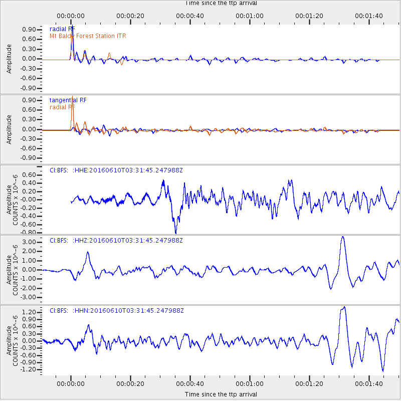
Signal To Noise
| Channel | StoN | STA | LTA |
| CI:BFS: :HHZ:20160610T03:31:45.247988Z | 7.2129364 | 5.3109557E-7 | 7.363098E-8 |
| CI:BFS: :HHN:20160610T03:31:45.247988Z | 3.7431235 | 1.6697888E-7 | 4.46095E-8 |
| CI:BFS: :HHE:20160610T03:31:45.247988Z | 3.763758 | 2.5023277E-7 | 6.6484816E-8 |
| Arrivals |
| Ps | 1.5 SECOND |
| PpPs | 4.4 SECOND |
| PsPs/PpSs | 5.9 SECOND |


