You are here: Home > Network List > CI - Caltech Regional Seismic Network Stations List
> Station FMP Fort MacArthur Park, Pt. Fermin San Pedro, CA, USA > Earthquake Result Viewer
FMP Fort MacArthur Park, Pt. Fermin San Pedro, CA, USA - Earthquake Result Viewer
| Earthquake location: |
Near Coast Of Nicaragua |
| Earthquake latitude/longitude: |
12.8/-87.0 |
| Earthquake time(UTC): |
2016/06/10 (162) 03:25:22 GMT |
| Earthquake Depth: |
10 km |
| Earthquake Magnitude: |
6.1 MWP |
| Earthquake Catalog/Contributor: |
NEIC PDE/NEIC COMCAT |
|
| Network: |
CI Caltech Regional Seismic Network |
| Station: |
FMP Fort MacArthur Park, Pt. Fermin San Pedro, CA, USA |
| Lat/Lon: |
33.71 N/118.29 W |
| Elevation: |
89 m |
|
| Distance: |
35.2 deg |
| Az: |
311.395 deg |
| Baz: |
118.627 deg |
| Ray Param: |
0.07732937 |
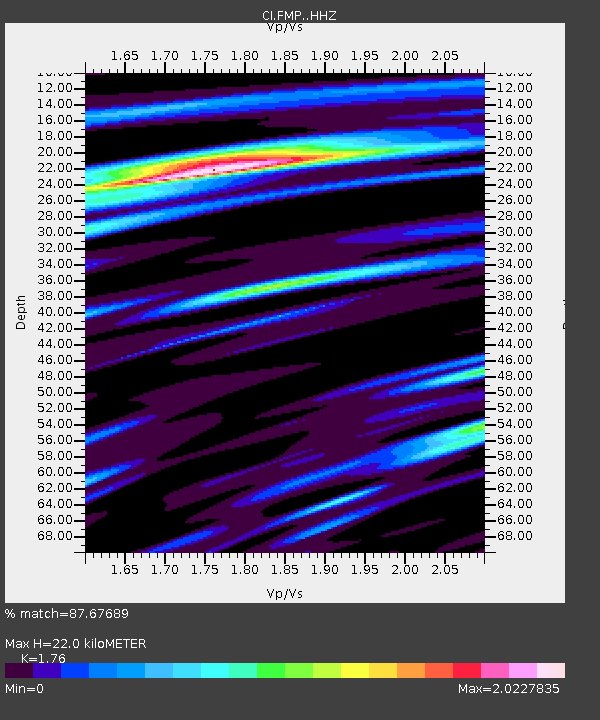
| Estimated Moho Depth: |
22.0 km |
| Estimated Crust Vp/Vs: |
1.76 |
| Assumed Crust Vp: |
6.048 km/s |
| Estimated Crust Vs: |
3.436 km/s |
| Estimated Crust Poisson's Ratio: |
0.26 |
|
| Radial Match: |
87.67689 % |
| Radial Bump: |
400 |
| Transverse Match: |
73.7856 % |
| Transverse Bump: |
400 |
| SOD ConfigId: |
7422571 |
| Insert Time: |
2019-04-22 19:33:14.462 +0000 |
| GWidth: |
2.5 |
| Max Bumps: |
400 |
| Tol: |
0.001 |
|
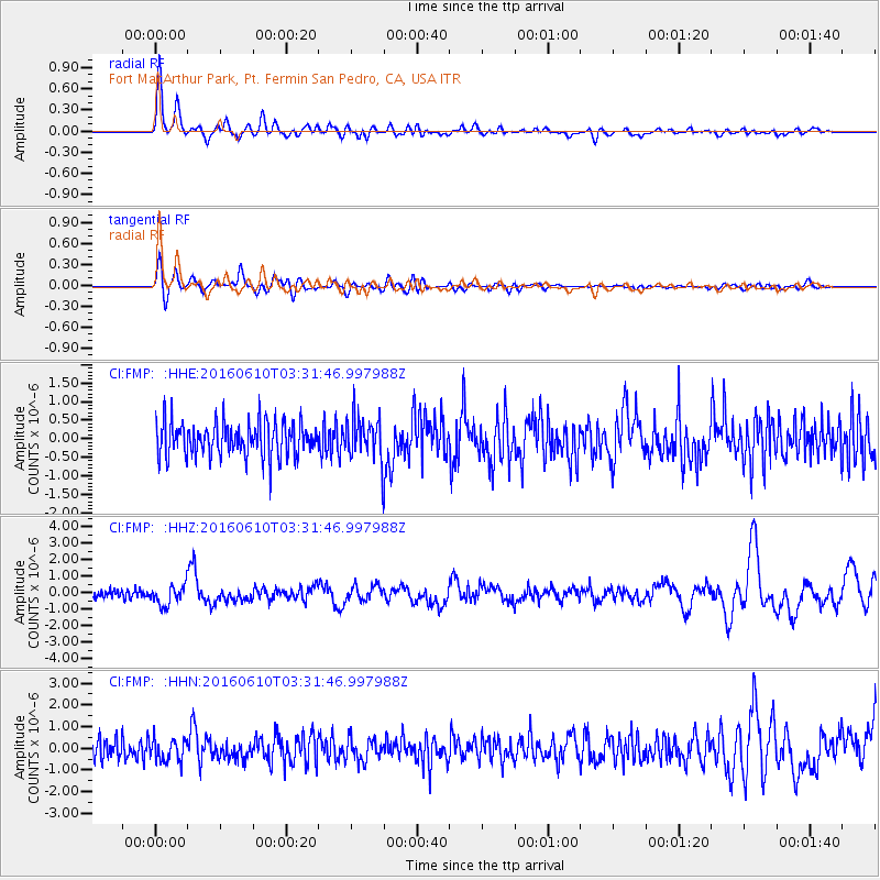
Signal To Noise
| Channel | StoN | STA | LTA |
| CI:FMP: :HHZ:20160610T03:31:46.997988Z | 2.6621952 | 6.067728E-7 | 2.2792197E-7 |
| CI:FMP: :HHN:20160610T03:31:46.997988Z | 1.0343617 | 5.184567E-7 | 5.012335E-7 |
| CI:FMP: :HHE:20160610T03:31:46.997988Z | 0.99504244 | 4.6666514E-7 | 4.6899018E-7 |
| Arrivals |
| Ps | 3.0 SECOND |
| PpPs | 9.4 SECOND |
| PsPs/PpSs | 12 SECOND |


