You are here: Home > Network List > IM - International Miscellaneous Stations Stations List
> Station NV31 NVAR Array Site 31, Mina, NV, USA > Earthquake Result Viewer
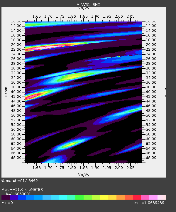
NV31 NVAR Array Site 31, Mina, NV, USA - Earthquake Result Viewer
| Earthquake location: |
Near Coast Of Nicaragua |
| Earthquake latitude/longitude: |
12.8/-87.0 |
| Earthquake time(UTC): |
2016/06/10 (162) 03:25:22 GMT |
| Earthquake Depth: |
10 km |
| Earthquake Magnitude: |
6.1 MWP |
| Earthquake Catalog/Contributor: |
NEIC PDE/NEIC COMCAT |
|
| Network: |
IM International Miscellaneous Stations |
| Station: |
NV31 NVAR Array Site 31, Mina, NV, USA |
| Lat/Lon: |
38.43 N/118.16 W |
| Elevation: |
1509 m |
|
| Distance: |
37.6 deg |
| Az: |
318.265 deg |
| Baz: |
124.24 deg |
| Ray Param: |
0.07604754 |
| Estimated Moho Depth: |
21.0 km |
| Estimated Crust Vp/Vs: |
1.69 |
| Assumed Crust Vp: |
6.279 km/s |
| Estimated Crust Vs: |
3.726 km/s |
| Estimated Crust Poisson's Ratio: |
0.23 |
|
| Radial Match: |
91.18462 % |
| Radial Bump: |
370 |
| Transverse Match: |
73.60976 % |
| Transverse Bump: |
400 |
| SOD ConfigId: |
7422571 |
| Insert Time: |
2019-04-22 19:35:29.915 +0000 |
| GWidth: |
2.5 |
| Max Bumps: |
400 |
| Tol: |
0.001 |
|

Signal To Noise
| Channel | StoN | STA | LTA |
| IM:NV31: :BHZ:20160610T03:32:07.125002Z | 18.38222 | 1.1918842E-6 | 6.483897E-8 |
| IM:NV31: :BHN:20160610T03:32:07.125002Z | 1.5008953 | 2.7176927E-7 | 1.8107144E-7 |
| IM:NV31: :BHE:20160610T03:32:07.125002Z | 6.379614 | 6.4402724E-7 | 1.00950814E-7 |
| Arrivals |
| Ps | 2.5 SECOND |
| PpPs | 8.3 SECOND |
| PsPs/PpSs | 11 SECOND |


