You are here: Home > Network List > N4 - Central and EAstern US Network Stations List
> Station L59A Walton, NY, USA > Earthquake Result Viewer
L59A Walton, NY, USA - Earthquake Result Viewer
| Earthquake location: |
Near Coast Of Nicaragua |
| Earthquake latitude/longitude: |
12.8/-87.0 |
| Earthquake time(UTC): |
2016/06/10 (162) 03:25:22 GMT |
| Earthquake Depth: |
10 km |
| Earthquake Magnitude: |
6.1 MWP |
| Earthquake Catalog/Contributor: |
NEIC PDE/NEIC COMCAT |
|
| Network: |
N4 Central and EAstern US Network |
| Station: |
L59A Walton, NY, USA |
| Lat/Lon: |
42.19 N/75.04 W |
| Elevation: |
677 m |
|
| Distance: |
31.0 deg |
| Az: |
17.393 deg |
| Baz: |
203.098 deg |
| Ray Param: |
0.07917405 |
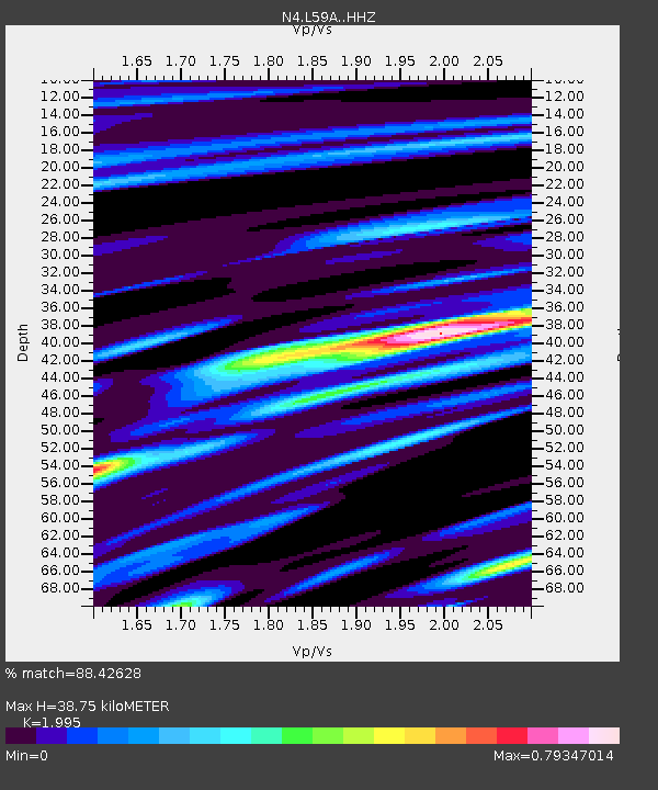
| Estimated Moho Depth: |
38.75 km |
| Estimated Crust Vp/Vs: |
2.00 |
| Assumed Crust Vp: |
6.419 km/s |
| Estimated Crust Vs: |
3.218 km/s |
| Estimated Crust Poisson's Ratio: |
0.33 |
|
| Radial Match: |
88.42628 % |
| Radial Bump: |
286 |
| Transverse Match: |
66.520996 % |
| Transverse Bump: |
394 |
| SOD ConfigId: |
7422571 |
| Insert Time: |
2019-04-22 19:36:42.812 +0000 |
| GWidth: |
2.5 |
| Max Bumps: |
400 |
| Tol: |
0.001 |
|

Signal To Noise
| Channel | StoN | STA | LTA |
| N4:L59A: :HHZ:20160610T03:31:10.079989Z | 10.735991 | 3.322578E-6 | 3.0948033E-7 |
| N4:L59A: :HHN:20160610T03:31:10.079989Z | 8.360141 | 1.9759832E-6 | 2.3635762E-7 |
| N4:L59A: :HHE:20160610T03:31:10.079989Z | 2.1004734 | 6.018832E-7 | 2.8654645E-7 |
| Arrivals |
| Ps | 6.4 SECOND |
| PpPs | 17 SECOND |
| PsPs/PpSs | 23 SECOND |


