You are here: Home > Network List > TA - USArray Transportable Network (new EarthScope stations) Stations List
> Station A21K Barrow, AK, USA > Earthquake Result Viewer
A21K Barrow, AK, USA - Earthquake Result Viewer
| Earthquake location: |
Near Coast Of Nicaragua |
| Earthquake latitude/longitude: |
12.8/-87.0 |
| Earthquake time(UTC): |
2016/06/10 (162) 03:25:22 GMT |
| Earthquake Depth: |
10 km |
| Earthquake Magnitude: |
6.1 MWP |
| Earthquake Catalog/Contributor: |
NEIC PDE/NEIC COMCAT |
|
| Network: |
TA USArray Transportable Network (new EarthScope stations) |
| Station: |
A21K Barrow, AK, USA |
| Lat/Lon: |
71.32 N/156.62 W |
| Elevation: |
577 m |
|
| Distance: |
71.4 deg |
| Az: |
341.423 deg |
| Baz: |
105.331 deg |
| Ray Param: |
0.054337762 |
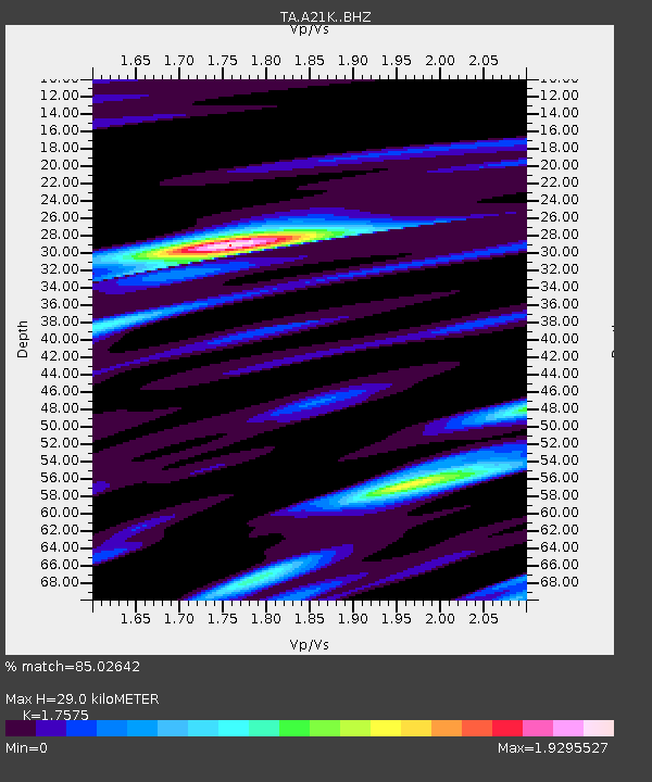
| Estimated Moho Depth: |
29.0 km |
| Estimated Crust Vp/Vs: |
1.76 |
| Assumed Crust Vp: |
6.048 km/s |
| Estimated Crust Vs: |
3.441 km/s |
| Estimated Crust Poisson's Ratio: |
0.26 |
|
| Radial Match: |
85.02642 % |
| Radial Bump: |
330 |
| Transverse Match: |
81.63436 % |
| Transverse Bump: |
328 |
| SOD ConfigId: |
7422571 |
| Insert Time: |
2019-04-22 19:38:25.423 +0000 |
| GWidth: |
2.5 |
| Max Bumps: |
400 |
| Tol: |
0.001 |
|

Signal To Noise
| Channel | StoN | STA | LTA |
| TA:A21K: :BHZ:20160610T03:36:12.150027Z | 11.774126 | 1.1058878E-6 | 9.392525E-8 |
| TA:A21K: :BHN:20160610T03:36:12.150027Z | 2.6967857 | 3.442697E-7 | 1.2765928E-7 |
| TA:A21K: :BHE:20160610T03:36:12.150027Z | 3.9984295 | 6.363469E-7 | 1.5914921E-7 |
| Arrivals |
| Ps | 3.7 SECOND |
| PpPs | 13 SECOND |
| PsPs/PpSs | 17 SECOND |


