You are here: Home > Network List > TA - USArray Transportable Network (new EarthScope stations) Stations List
> Station G03D McMinnville, OR, USA > Earthquake Result Viewer
G03D McMinnville, OR, USA - Earthquake Result Viewer
| Earthquake location: |
Near Coast Of Nicaragua |
| Earthquake latitude/longitude: |
12.8/-87.0 |
| Earthquake time(UTC): |
2016/06/10 (162) 03:25:22 GMT |
| Earthquake Depth: |
10 km |
| Earthquake Magnitude: |
6.1 MWP |
| Earthquake Catalog/Contributor: |
NEIC PDE/NEIC COMCAT |
|
| Network: |
TA USArray Transportable Network (new EarthScope stations) |
| Station: |
G03D McMinnville, OR, USA |
| Lat/Lon: |
45.21 N/123.26 W |
| Elevation: |
222 m |
|
| Distance: |
44.6 deg |
| Az: |
323.457 deg |
| Baz: |
124.76 deg |
| Ray Param: |
0.071824335 |
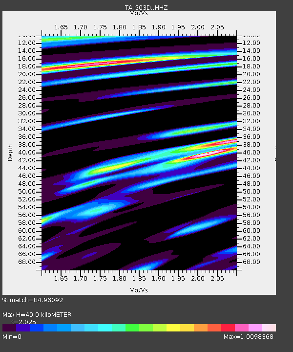
| Estimated Moho Depth: |
40.0 km |
| Estimated Crust Vp/Vs: |
2.03 |
| Assumed Crust Vp: |
6.566 km/s |
| Estimated Crust Vs: |
3.243 km/s |
| Estimated Crust Poisson's Ratio: |
0.34 |
|
| Radial Match: |
84.96092 % |
| Radial Bump: |
400 |
| Transverse Match: |
53.87026 % |
| Transverse Bump: |
400 |
| SOD ConfigId: |
7422571 |
| Insert Time: |
2019-04-22 19:38:31.744 +0000 |
| GWidth: |
2.5 |
| Max Bumps: |
400 |
| Tol: |
0.001 |
|
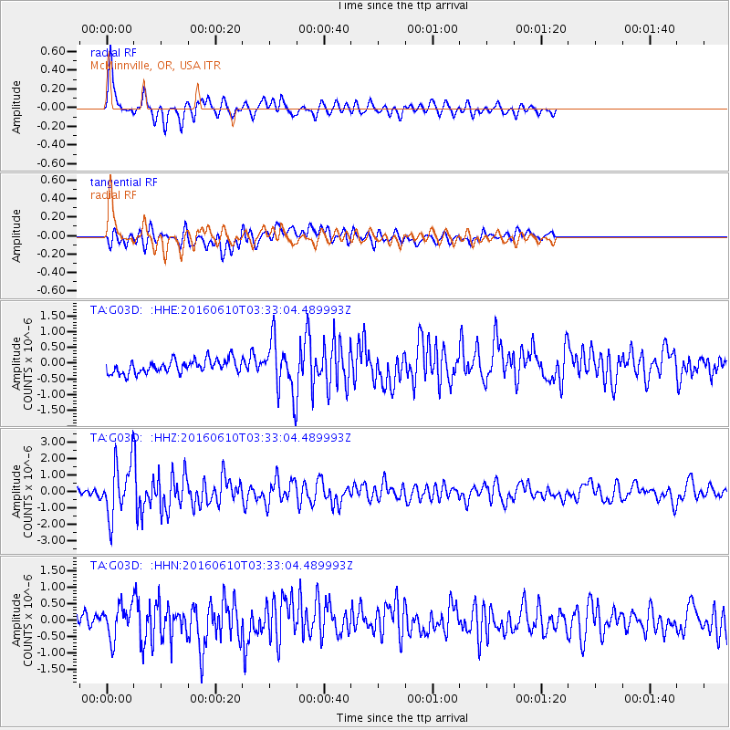
Signal To Noise
| Channel | StoN | STA | LTA |
| TA:G03D: :HHZ:20160610T03:33:04.489993Z | 10.507366 | 1.632982E-6 | 1.5541308E-7 |
| TA:G03D: :HHN:20160610T03:33:04.489993Z | 2.544881 | 4.995051E-7 | 1.9627836E-7 |
| TA:G03D: :HHE:20160610T03:33:04.489993Z | 3.347629 | 7.047354E-7 | 2.1051775E-7 |
| Arrivals |
| Ps | 6.6 SECOND |
| PpPs | 17 SECOND |
| PsPs/PpSs | 24 SECOND |


